
南京市 topographic map
Interactive map
Click on the map to display elevation.
About this map
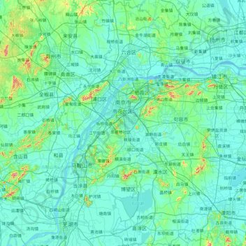
Name: 南京市 topographic map, elevation, terrain.
Location: 南京市, 江苏省, 中国 (31.22675 118.33459 32.61578 119.23951)
Average elevation: 28 m
Minimum elevation: -1 m
Maximum elevation: 418 m
南京市地貌特征属宁镇扬丘陵地区。其中,低山丘陵面积为4255.07平方千米、江河面积752.06平方千米、圩洲面积1589.88平方千米。从地形组成来看,低山占土地总面积的3.5%,丘陵占4.3%,岗地占53%,平原、洼地及河流湖泊占土地总面积的39.2%。长江从西南方向流入南京,在此折向东进入镇江。秦淮河、滁河分别从南北岸汇入长江。
Other topographic maps
Click on a map to view its topography, its elevation and its terrain.