
Baltimore County topographic map
Interactive map
Click on the map to display elevation.
About this map
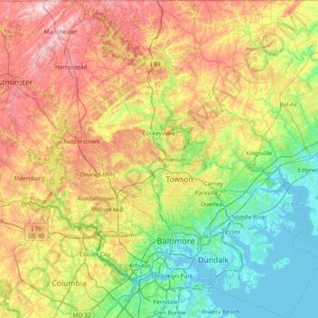
Name: Baltimore County topographic map, elevation, terrain.
Location: Baltimore County, Maryland, United States (39.15168 -76.89656 39.72118 -76.27149)
Average elevation: 123 m
Minimum elevation: -3 m
Maximum elevation: 339 m
According to the United States Census Bureau, the county covers 682 square miles (1,770 km2), of which 598 square miles (1,550 km2) are land and 83 square miles (210 km2) (12%) are water. It is the third-largest county in Maryland by land area. The larger portion of the terrain is undulating, with bold hills often rising to a height of 800 feet (240 m) above tide water. The highest elevation is approximately 960 feet (290 m) above sea level, along the Pennsylvania state line near Steltz. The lowest elevation is sea level along the shoreline of Chesapeake Bay.
Other topographic maps
Click on a map to view its topography, its elevation and its terrain.
Anne Arundel County
Anne Arundel County, Maryland, United States
Average elevation: 25 m
Lake Bernard Frank
United States > Maryland > Montgomery County
Lake Bernard Frank, Montgomery County, Maryland, United States
Average elevation: 114 m
Rockville
United States > Maryland > Montgomery County
Rockville, Montgomery County, Maryland, United States
Average elevation: 122 m
Chesapeake Forest - Aughty Naughty Complex
United States > Maryland > Wicomico County
Chesapeake Forest - Aughty Naughty Complex, Wicomico County, Maryland, United States
Average elevation: 9 m
Gravely
United States > Maryland > Anne Arundel County
Gravely, Anne Arundel County, Maryland, 21035, United States
Average elevation: 35 m
Mayo
United States > Maryland > Anne Arundel County
Mayo, Anne Arundel County, Maryland, 21106, United States
Average elevation: 2 m
McHenry
United States > Maryland > Garrett County
McHenry, Garrett County, Maryland, 21541, United States
Average elevation: 817 m
Silver Spring
United States > Maryland > Montgomery County > Silver Spring
Silver Spring, Montgomery County, Maryland, United States
Average elevation: 86 m
Dundalk
United States > Maryland > Baltimore County > Dundalk
Dundalk, Baltimore County, Maryland, 21222, United States
Average elevation: 6 m
Mays Chapel
United States > Maryland > Baltimore County > Mays Chapel
Mays Chapel, Baltimore County, Maryland, 21093, United States
Average elevation: 129 m
Middle East
United States > Maryland > Baltimore
Middle East, Baltimore, Maryland, United States
Average elevation: 29 m
Fort Meade
United States > Maryland > Anne Arundel County > Fort Meade
Fort Meade, Anne Arundel County, Maryland, United States
Average elevation: 53 m
Saint Mary's County
Saint Mary's County, Maryland, United States
Average elevation: 13 m
Oldtown
United States > Maryland > Oldtown
Oldtown, Allegany County, Maryland, 26722, United States
Average elevation: 194 m
Croom
United States > Maryland > Prince George's County > Croom
Croom, Prince George's County, Maryland, United States
Average elevation: 47 m