
Anne Arundel County topographic map
Interactive map
Click on the map to display elevation.
About this map
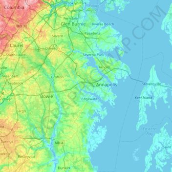
Name: Anne Arundel County topographic map, elevation, terrain.
Location: Anne Arundel County, Maryland, United States (38.70925 -76.84033 39.23711 -76.34858)
Average elevation: 25 m
Minimum elevation: -3 m
Maximum elevation: 161 m
Elevations in Anne Arundel County range from sea level at the Chesapeake and tidal tributaries to about 300 feet (91 m) in western areas near the fall line. The terrain is mostly flat or gently rolling, but more dramatic banks and bluffs can be found where waterways cut through areas of higher elevation.
Other topographic maps
Click on a map to view its topography, its elevation and its terrain.
Lake Bernard Frank
United States > Maryland > Montgomery County
Lake Bernard Frank, Montgomery County, Maryland, United States
Average elevation: 114 m
Rockville
United States > Maryland > Montgomery County
Rockville, Montgomery County, Maryland, United States
Average elevation: 122 m
Chesapeake Forest - Aughty Naughty Complex
United States > Maryland > Wicomico County
Chesapeake Forest - Aughty Naughty Complex, Wicomico County, Maryland, United States
Average elevation: 9 m
Gravely
United States > Maryland > Anne Arundel County
Gravely, Anne Arundel County, Maryland, 21035, United States
Average elevation: 35 m
Mayo
United States > Maryland > Anne Arundel County
Mayo, Anne Arundel County, Maryland, 21106, United States
Average elevation: 2 m
McHenry
United States > Maryland > Garrett County
McHenry, Garrett County, Maryland, 21541, United States
Average elevation: 817 m
Silver Spring
United States > Maryland > Montgomery County > Silver Spring
Silver Spring, Montgomery County, Maryland, United States
Average elevation: 86 m
Dundalk
United States > Maryland > Baltimore County > Dundalk
Dundalk, Baltimore County, Maryland, 21222, United States
Average elevation: 6 m
Mays Chapel
United States > Maryland > Baltimore County > Mays Chapel
Mays Chapel, Baltimore County, Maryland, 21093, United States
Average elevation: 129 m
Middle East
United States > Maryland > Baltimore
Middle East, Baltimore, Maryland, United States
Average elevation: 29 m
Fort Meade
United States > Maryland > Anne Arundel County > Fort Meade
Fort Meade, Anne Arundel County, Maryland, United States
Average elevation: 53 m
Baltimore County
Baltimore County, Maryland, United States
Average elevation: 123 m
Saint Mary's County
Saint Mary's County, Maryland, United States
Average elevation: 13 m
Oldtown
United States > Maryland > Oldtown
Oldtown, Allegany County, Maryland, 26722, United States
Average elevation: 194 m
Croom
United States > Maryland > Prince George's County > Croom
Croom, Prince George's County, Maryland, United States
Average elevation: 47 m