
Samegrelo-Upper Svaneti topographic map
Interactive map
Click on the map to display elevation.
About this map
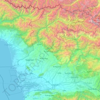
Name: Samegrelo-Upper Svaneti topographic map, elevation, terrain.
Location: Samegrelo-Upper Svaneti, Georgia (42.01441 41.29024 43.25698 43.14623)
Average elevation: 1,104 m
Minimum elevation: -2 m
Maximum elevation: 5,127 m
Other topographic maps
Click on a map to view its topography, its elevation and its terrain.
Tbilisi
Most of the raions are named after historic quarters of the city. The citizens of Tbilisi widely recognise an informal system of smaller historic neighbourhoods. Such neighbourhoods are several, however, constituting a kind of hierarchy, because most of them have lost their distinctive topographic limits. The…
Average elevation: 713 m
Mestia
Georgia > Samegrelo-Upper Svaneti > Mestia Municipality
Mestia (Georgian: მესტია IPA: [mestʼia]) is a highland townlet (daba) in northwest Georgia, at an elevation of 1,500 metres (4,921 feet) in the Caucasus Mountains.
Average elevation: 1,749 m
Gudauri
Georgia > Mtskheta-Mtianeti > Kazbegi Municipality
Gudauri (Georgian: გუდაური) is a ski resort located on the south-facing plateau of The Greater Caucasus Mountain Range in Georgia. The resort is situated in the Stepantsminda District, along the Georgian Military Highway near the Jvari Pass, at an elevation of 2,200 meters (7,200 ft.) above sea…
Average elevation: 2,161 m
Bakuriani
Georgia > Samtskhe-Javakheti > Borjomi Municipality
Bakuriani (Georgian: ბაკურიანი) is a daba and a ski resort in the Borjomi district of Georgia. It is located on the northern slope of the Trialeti Range, at an elevation of 1,700 meters (5,576 feet) above sea level.
Average elevation: 1,756 m
Mountain Makhuntseti
Georgia > Autonomous Republic of Adjara > Keda Municipality
Average elevation: 1,067 m
Mami
Georgia > Racha-Lechkhumi and Lower Svaneti > Lentekhi Municipality > Mami
Average elevation: 1,417 m