
Make a donation
Gear up for your next adventure:
As an Amazon Associate, this site earns from qualifying purchases at no extra cost to you.
Tsdo topographic map
Click on the map to display elevation.
Make a donation
Gear up for your next adventure:
As an Amazon Associate, this site earns from qualifying purchases at no extra cost to you.
About this map
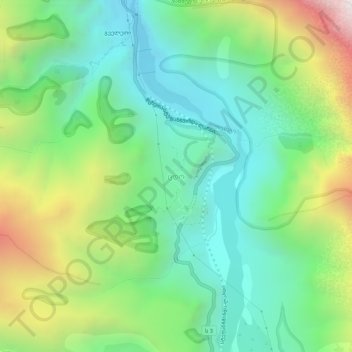
Name: Tsdo topographic map, elevation, terrain.
Location: Tsdo, Kazbegi Municipality, Mtskheta-Mtianeti, 4700, Georgia (42.67220 44.61319 42.71220 44.65319)
Average elevation: 1,946 m
Minimum elevation: 1,417 m
Maximum elevation: 3,052 m
Make a donation
Gear up for your next adventure:
As an Amazon Associate, this site earns from qualifying purchases at no extra cost to you.
Other topographic maps
Click on a map to view its topography, its elevation and its terrain.
Stepantsminda
Georgia > Mtskheta-Mtianeti > Kazbegi Municipality
The town is located along the banks of the Terek River, 157 kilometers (98 mi) to the north of Tbilisi at an elevation of 1,740 meters (5,710 feet) above sea level. Stepantsminda’s climate is moderately humid with relatively dry, cold winters and long and cool summers. The average annual temperature is 4.9…
Average elevation: 1,851 m