
Gotland topographic map
Interactive map
Click on the map to display elevation.
About this map
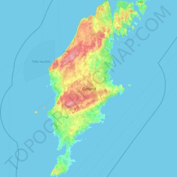
Name: Gotland topographic map, elevation, terrain.
Location: Gotland, Sweden (56.90509 18.09136 57.92974 19.09822)
Average elevation: 6 m
Minimum elevation: -1 m
Maximum elevation: 80 m
Other topographic maps
Click on a map to view its topography, its elevation and its terrain.
Uppsala
Situated on the fertile Uppsala flatlands of muddy soil, the city features the small Fyris River (Fyrisån) flowing through the landscape surrounded by lush vegetation. Parallel to the river runs the glacial ridge of Uppsalaåsen at an elevation around 30 m (98 ft), the site of Uppsala's castle, from which…
Average elevation: 29 m
Nyköping
Nyköping is the exodus of a small river named Nyköpingsån (Nyköping River), which runs through the city centre, dividing the city into a natural eastern and western part. Due to the narrowness of the river, there are a full seven crossings available for automobile traffic, one of them being for the E4. For…
Average elevation: 19 m
Södertälje
Due to its topography and the fact that it is divided by a canal, it has been difficult to build good train connections in and through the city. Despite this, Södertälje is one of the largest railway hubs in Sweden. When the railway to Södertälje was commissioned, it was decided that the main line would…
Average elevation: 38 m
Östersund
Though Östersund is in fact affected by the Gulf Stream, it lacks the high frequency of rain or snow following the currents. This is due to the Scandinavian Mountain Range acting as a natural barrier, receiving most of the precipitation, giving Östersund and the surrounding area a rain deficit. Another issue…
Average elevation: 341 m