
Make a donation
Gear up for your next adventure:
As an Amazon Associate, this site earns from qualifying purchases at no extra cost to you.
Nyköping topographic map
Click on the map to display elevation.
Make a donation
Gear up for your next adventure:
As an Amazon Associate, this site earns from qualifying purchases at no extra cost to you.
Nyköping
Nyköping is the exodus of a small river named Nyköpingsån (Nyköping River), which runs through the city centre, dividing the city into a natural eastern and western part. Due to the narrowness of the river, there are a full seven crossings available for automobile traffic, one of them being for the E4. For pedestrians and bikers, an additional seven bridges are available, and in addition to that there's also one bridge for train traffic. All automobile bridges except E4 also carry pedestrian sidewalks, which means transport is seldom made longer than the actual distance. There is also a small pedestrian bridge in an unpopulated nature reserve called Hållet that is very close to the E4 route. The small river Kilaån separates Nyköping and Arnö, with that river being even narrower. Also separating Nyköping and Arnö is the so-called Stadsfjärden (the City bay), which is a bay stretching around the Arnö peninsula down to the neighboring municipality of Oxelösund. Stadsfjärden is primarily used for tourist shipping and canoeing, with an internationally renowned canoeing stadium being situated along the northern shore. The port is much smaller than Oxelösund's and is primarily used for civil traffic, as opposed to cargo shipments and ferry traffic which is dominated by nearby ports of Oxelösund and Nynäshamn. This is due to the port being some 15 kilometres from open sea as opposed to Oxelösund's position on the edge of the peninsula. Even though Nyköping is a relatively flat city there are some hills in the northern parts of the town, barely reaching 50 metres altitude. The city centre is essentially just above sea level and doesn't rise above 20 metres altitude, although it contains hills surrounding it.
Make a donation
Gear up for your next adventure:
As an Amazon Associate, this site earns from qualifying purchases at no extra cost to you.
About this map
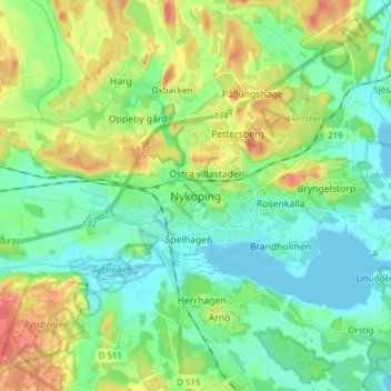
Name: Nyköping topographic map, elevation, terrain.
Average elevation: 19 m
Minimum elevation: -2 m
Maximum elevation: 57 m
Make a donation
Gear up for your next adventure:
As an Amazon Associate, this site earns from qualifying purchases at no extra cost to you.