
Make a donation
Gear up for your next adventure:
As an Amazon Associate, this site earns from qualifying purchases at no extra cost to you.
Samtskhe-Javakheti topographic map
Click on the map to display elevation.
Make a donation
Gear up for your next adventure:
As an Amazon Associate, this site earns from qualifying purchases at no extra cost to you.
About this map
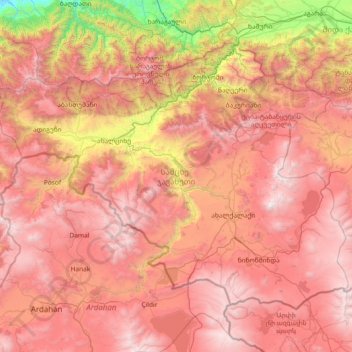
Name: Samtskhe-Javakheti topographic map, elevation, terrain.
Location: Samtskhe-Javakheti, Georgia (41.10933 42.49199 41.94390 43.96659)
Average elevation: 1,818 m
Minimum elevation: 122 m
Maximum elevation: 3,277 m
Make a donation
Gear up for your next adventure:
As an Amazon Associate, this site earns from qualifying purchases at no extra cost to you.
Other topographic maps
Click on a map to view its topography, its elevation and its terrain.
Tbilisi
Most of the raions are named after historic quarters of the city. The citizens of Tbilisi widely recognise an informal system of smaller historic neighbourhoods. Such neighbourhoods are several, however, constituting a kind of hierarchy, because most of them have lost their distinctive topographic limits. The…
Average elevation: 713 m
Make a donation
Gear up for your next adventure:
As an Amazon Associate, this site earns from qualifying purchases at no extra cost to you.
Gudauri
Georgia > Mtskheta-Mtianeti > Kazbegi Municipality
Gudauri (Georgian: გუდაური) is a ski resort located on the south-facing plateau of The Greater Caucasus Mountain Range in Georgia. The resort is situated in the Stepantsminda District, along the Georgian Military Highway near the Jvari Pass, at an elevation of 2,200 meters (7,200 ft.) above sea…
Average elevation: 2,161 m
Mestia
Georgia > Samegrelo-Upper Svaneti > Mestia Municipality
Mestia (Georgian: მესტია IPA: [mestʼia]) is a highland townlet (daba) in northwest Georgia, at an elevation of 1,500 metres (4,921 feet) in the Caucasus Mountains.
Average elevation: 1,749 m
Make a donation
Gear up for your next adventure:
As an Amazon Associate, this site earns from qualifying purchases at no extra cost to you.
Make a donation
Gear up for your next adventure:
As an Amazon Associate, this site earns from qualifying purchases at no extra cost to you.
Mountain Makhuntseti
Georgia > Autonomous Republic of Adjara > Keda Municipality
Average elevation: 1,067 m
Make a donation
Gear up for your next adventure:
As an Amazon Associate, this site earns from qualifying purchases at no extra cost to you.
Mami
Georgia > Racha-Lechkhumi and Lower Svaneti > Lentekhi Municipality > Mami
Average elevation: 1,417 m