
Guanajuato topographic map
Interactive map
Click on the map to display elevation.
About this map
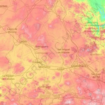
Name: Guanajuato topographic map, elevation, terrain.
Location: Guanajuato, Mexico (19.91275 -102.09728 21.83942 -99.67130)
Average elevation: 2,005 m
Minimum elevation: 873 m
Maximum elevation: 3,508 m
Los Valles del Sur, also called the Valles Abajeños, are valleys located in the southwest part of the state, bordering the state of Michoacán. This area is distinguished by the large number of Purépecha place names and covers the municipalities of Valle de Santiago, Yuriria, Tarimoro, Apaseo el Alto, Moroleón, Uriangato, Santiago Maravatío, Acámbaro, Jerécuaro, Coroneo and Tarandacuao. The area is part of the Trans-Mexican Volcanic Belt with elevations ranging between 1,700 and 2,000 meters. The soil is fertile due to its volcanic base, producing crops such as sorghum, wheat, corn and vegetables. The land also produces building materials such as tezontle and black sandstone. In the higher elevations, there are forests of pine and holm oak but these have been much reduced because of deforestation. In the more arid areas, mesquite, nopal and other desert plants can be found. There are several small lakes, the best known being the Yuriria Lake as well as canyons and cave systems, some of which were used for ceremonial purposes by pre-Hispanic peoples. It is also the home the Siete Luminarias de Valle de Santiago, a set of seven inactive volcanic craters located in the northwest and southwest of the Santiago Valley. The volcano cones rise abruptly out of the ground with craters that measure up to one kilometer across. Locals call the formations "holes" (hoyos) and they are named La Alberca, La Cíntora, Estrada, Blanca, Alvarez, Solís and Rincón de Parangueo. La Cíntora and Rincón de Parangueo contain cave paintings and evidence that people once lived in the craters. La Alberca (The Pool) is a crater lake which is open to the public for swimming, rowing or boating. The name of "Siete Luminarias" (Seven Lanterns) comes from an imagined time when the seven were active at once in prehistory.
Other topographic maps
Click on a map to view its topography, its elevation and its terrain.
Malpasito
Mexico > Tabasco > Huimanguillo
Malpasito, Huimanguillo, Tabasco, Mexico
Average elevation: 241 m
El Lencero
Mexico > Veracruz > Emiliano Zapata
El Lencero, Emiliano Zapata, Veracruz, 91640, Mexico
Average elevation: 1,001 m
Cancun
Mexico > Quintana Roo > Benito Juárez > Cancun
Cancun, Benito Juárez, Quintana Roo, Mexico
Average elevation: 5 m
Sierra Madre Occidental
Sierra Madre Occidental, Guadalupe y Calvo, Chihuahua, Mexico
Average elevation: 2,945 m
Ciudad Constitución
Mexico > Baja California Sur > Municipio de Comondú > Ciudad Constitución
Ciudad Constitución, Municipio de Comondú, Baja California Sur, 23600, Mexico
Average elevation: 54 m
Isla Mujeres
Mexico > Quintana Roo > Isla Mujeres
Isla Mujeres, Municipio de Isla Mujeres, Quintana Roo, Mexico
Average elevation: 0 m
Sian Ka'an
Mexico > Quintana Roo > Punta Allen
Sian Ka'an, Calle Punta Nizuc, Punta Allen, Tulum, Quintana Roo, Mexico
Average elevation: 4 m
Sierra Madre Oriental
Sierra Madre Oriental, Galeana, Nuevo León, Mexico
Average elevation: 3,072 m
Ensenada
Mexico > Baja California > Ensenada
Ensenada, Baja California, Mexico
Average elevation: 184 m
Ecatepec de Morelos
Mexico > State of Mexico > Ecatepec de Morelos
Ecatepec de Morelos, State of Mexico, Mexico
Average elevation: 2,288 m
La Cañada
Mexico > Querétaro > Pinal de Amoles > La Cañada
La Cañada, Pinal de Amoles, Querétaro, Mexico
Average elevation: 2,575 m
El Campanario
Mexico > State of Mexico > El Campanario
El Campanario, Luvianos, State of Mexico, Mexico
Average elevation: 1,050 m
Micos Waterfalls
Mexico > San Luis Potosi > Ciudad Valles
Micos Waterfalls, Ciudad Valles, San Luis Potosi, 79000, Mexico
Average elevation: 291 m
Colonia Mangos (El Quemado)
Mexico > Guerrero > Colonia Mangos (El Quemado)
Colonia Mangos (El Quemado), Acapulco de Juárez, Guerrero, 39700, Mexico
Average elevation: 69 m
Antúnez (Morelos)
Mexico > Michoacán > Antúnez (Morelos)
Antúnez (Morelos), Parácuaro, Michoacán, Mexico
Average elevation: 361 m
San Sebastián de Aparicio
Mexico > Puebla > San Sebastián de Aparicio
San Sebastián de Aparicio, Puebla, 72228, Mexico
Average elevation: 2,279 m
Camino Real
Camino Real, Terrenos del Lote Tancoco, Tancoco, Veracruz, Mexico
Average elevation: 534 m
Chicoloapan
Mexico > Mexico > Chicoloapan
Chicoloapan, Mexico, 56386, Mexico
Average elevation: 2,276 m
Gustavo A. Madero
Gustavo A. Madero, Mexico City, Mexico
Average elevation: 2,305 m
Santa María Magdalena
Mexico > Hidalgo > Santa María Magdalena
Santa María Magdalena, Tepeji del Río de Ocampo, Hidalgo, Mexico
Average elevation: 2,152 m