
Denver topographic map
Interactive map
Click on the map to display elevation.
About this map
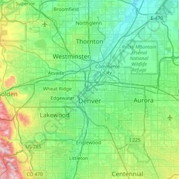
Name: Denver topographic map, elevation, terrain.
Location: Denver, Colorado, United States (39.61430 -105.10988 39.91421 -104.59970)
Average elevation: 1,684 m
Minimum elevation: 1,515 m
Maximum elevation: 2,397 m
Denver is located in the Western United States, in the South Platte River Valley on the western edge of the High Plains just east of the Front Range of the Rocky Mountains. Its downtown district is immediately east of the confluence of Cherry Creek and the South Platte River, approximately 12 mi (19 km) east of the foothills of the Rocky Mountains. It is named after James W. Denver, a governor of the Kansas Territory. It is nicknamed the Mile High City because its official elevation is exactly one mile (5280 feet or 1609.344 meters) above sea level.[a][16] The 105th meridian west of Greenwich, the longitudinal reference for the Mountain Time Zone, passes directly through Denver Union Station.
Other topographic maps
Click on a map to view its topography, its elevation and its terrain.
Douglas County
Douglas County, Colorado, United States
Average elevation: 2,104 m
Evans
United States > Colorado > Weld County
Evans, Weld County, Colorado, United States
Average elevation: 1,429 m
Castle Rock
United States > Colorado > Douglas County
Castle Rock, Douglas County, Colorado, United States
Average elevation: 1,952 m
Dolores County
Dolores County, Colorado, United States, Mount Wilson
Average elevation: 3,892 m
Creede
United States > Colorado > Mineral County
Creede, Mineral County, Colorado, United States
Average elevation: 2,891 m
Estes Park
United States > Colorado > Larimer County
Estes Park, Larimer County, Colorado, 80517, United States
Average elevation: 2,421 m
Manitou Springs
United States > Colorado > El Paso County
Manitou Springs, El Paso County, Colorado, 80829, United States
Average elevation: 2,144 m
Steamboat Springs
United States > Colorado > Routt County > Steamboat Springs
Steamboat Springs, Routt County, Colorado, United States
Average elevation: 2,228 m
Rustic
United States > Colorado > Rustic
Rustic, Larimer County, Colorado, United States
Average elevation: 2,390 m
Colorado Springs
United States > Colorado > Colorado Springs
Colorado Springs, El Paso County, Colorado, United States
Average elevation: 2,252 m
Denver
United States > Colorado > Denver
Denver, Denver County, Colorado, United States
Average elevation: 1,684 m
San Miguel County
San Miguel County, Colorado, United States
Average elevation: 2,390 m
San Juan County
San Juan County, Colorado, 81433, United States
Average elevation: 3,478 m
The Flat Tops
The Flat Tops, Mesa County, Colorado, United States
Average elevation: 3,207 m
Boulder County
United States > Colorado > Boulder County
Boulder County, Colorado, United States
Average elevation: 2,308 m
Montezuma County
Montezuma County, Colorado, United States
Average elevation: 2,025 m