
Connecticut topographic map
Interactive map
Click on the map to display elevation.
About this map
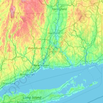
Name: Connecticut topographic map, elevation, terrain.
Location: Connecticut, United States (40.95098 -73.72781 42.05058 -71.78724)
Average elevation: 118 m
Minimum elevation: -3 m
Maximum elevation: 780 m
Winters (December through mid-March) are generally cold from south to north in Connecticut. The coldest month (January) has average high temperatures ranging from 38 °F (3 °C) in the coastal lowlands to 33 °F (1 °C) in the inland and northern portions on the state. The average yearly snowfall ranges from about 60 inches (1,500 mm) in the higher elevations of the northern portion of the state to only 20–25 inches (510–640 mm) along the southeast coast of Connecticut (Branford to Groton). Generally, any locale north or west of Interstate 84 receives the most snow, during a storm, and throughout the season. Most of Connecticut has less than 60 days of snow cover. Snow usually falls from late November to late March in the northern part of the state, and from early December to mid-March in the southern and coastal parts of the state.
Other topographic maps
Click on a map to view its topography, its elevation and its terrain.
Monterey County
Monterey County, California, United States
Average elevation: 282 m
El Dorado County
El Dorado County, California, United States
Average elevation: 1,286 m
Victorville
United States > California > San Bernardino County
Victorville, San Bernardino County, California, United States
Average elevation: 920 m
Dallas
United States > Texas > Dallas County
Dallas, Dallas County, Texas, United States
Average elevation: 160 m
San Bernardino County
San Bernardino County, California, United States
Average elevation: 763 m
Corvallis
United States > Oregon > Benton County
Corvallis, Benton County, Oregon, United States
Average elevation: 81 m
Newburyport
United States > Massachusetts > Essex County > Newburyport
Newburyport, Essex County, Massachusetts, 01950, United States
Average elevation: 9 m
Anne Arundel County
Anne Arundel County, Maryland, United States
Average elevation: 25 m
Port Saint Lucie
United States > Florida > Saint Lucie County
Port Saint Lucie, Saint Lucie County, Florida, United States
Average elevation: 7 m
Oakton
United States > Virginia > Fairfax County
Oakton, Fairfax County, Virginia, 20030, United States
Average elevation: 114 m
Saint Petersburg
United States > Florida > Pinellas County
Saint Petersburg, Pinellas County, Florida, United States
Average elevation: 3 m
Springfield
United States > Virginia > Fairfax County > Springfield
Springfield, Fairfax County, Virginia, 22150, United States
Average elevation: 68 m
Lorton
United States > Virginia > Fairfax County
Lorton, Fairfax County, Virginia, United States
Average elevation: 41 m
Delaware County
Delaware County, Indiana, United States
Average elevation: 288 m
Chino
United States > California > San Bernardino County
Chino, San Bernardino County, California, United States
Average elevation: 239 m
Town of Ithaca
United States > New York > Tompkins County
Town of Ithaca, Tompkins County, New York, United States
Average elevation: 288 m
Hamden
United States > Connecticut > South Central Connecticut Planning Region
Hamden, South Central Connecticut Planning Region, Connecticut, United States
Average elevation: 64 m
Obion County
Obion County, West Tennessee, Tennessee, United States
Average elevation: 103 m
Lake Bernard Frank
United States > Maryland > Montgomery County
Lake Bernard Frank, Montgomery County, Maryland, United States
Average elevation: 114 m
Hopedale
United States > Illinois > Tazewell County
Hopedale, Tazewell County, Illinois, United States
Average elevation: 195 m
Helena
United States > Montana > Lewis and Clark County
Helena, Lewis and Clark County, Montana, United States
Average elevation: 1,296 m
Morristown
United States > New Jersey > Morris County
Morristown, Morris County, New Jersey, 07960, United States
Average elevation: 123 m
Nacogdoches County
Nacogdoches County, Texas, United States
Average elevation: 93 m
Serrano Village
United States > California > San Bernardino County > San Bernardino
Serrano Village, San Bernardino, San Bernardino County, California, 92405, United States
Average elevation: 489 m
Horry County
United States > South Carolina
Horry County, South Carolina, United States
Average elevation: 14 m
San Diego
United States > California > San Diego County
San Diego, San Diego County, California, United States
Average elevation: 125 m
Phoenix
United States > Arizona > Maricopa County
Phoenix, Maricopa County, Arizona, United States
Average elevation: 481 m
Sheep Islands
United States > North Carolina > Carteret County
Sheep Islands, Carteret County, North Carolina, United States
Average elevation: 0 m
Millport
United States > Alabama > Lamar County
Millport, Lamar County, Alabama, United States
Average elevation: 94 m
Alta
United States > Utah > Salt Lake County
Alta, Salt Lake County, Utah, United States
Average elevation: 2,912 m
Clearwater County
Clearwater County, Idaho, United States
Average elevation: 1,250 m
Belton
United States > Missouri > Cass County
Belton, Cass County, Missouri, 64012, United States
Average elevation: 319 m
Cabot
United States > Pennsylvania > Butler County > Knox Chapel
Cabot, Knox Chapel, Winfield Township, Butler County, Pennsylvania, 16023, United States
Average elevation: 397 m
Timber Lake Manor
United States > Arkansas > Baxter County
Timber Lake Manor, Baxter County, Arkansas, 72531, United States
Average elevation: 191 m
Wood Oaks Green Park Sled Hill
United States > Illinois > Cook County > Northbrook
Wood Oaks Green Park Sled Hill, Northbrook, Northfield Township, Cook County, Illinois, 60062, United States
Average elevation: 202 m
Fayette County
Fayette County, Pennsylvania, United States
Average elevation: 450 m
Westport
United States > Connecticut > Western Connecticut Planning Region
Westport, Western Connecticut Planning Region, Connecticut, 06880, United States
Average elevation: 22 m
Visalia
United States > California > Tulare County
Visalia, Tulare County, California, United States
Average elevation: 102 m
Albuquerque
United States > New Mexico > Bernalillo County
Albuquerque, Bernalillo County, New Mexico, United States
Average elevation: 1,688 m
Atlantic Beach
United States > Florida > Duval County
Atlantic Beach, Duval County, Florida, 32233, United States
Average elevation: 2 m
Rockville
United States > Maryland > Montgomery County
Rockville, Montgomery County, Maryland, United States
Average elevation: 122 m
Lagoon Heights
United States > Massachusetts > Dukes County > Oak Bluffs
Lagoon Heights, Oak Bluffs, Dukes County, Massachusetts, 02557, United States
Average elevation: 5 m
Livingston County
Livingston County, Kentucky, United States
Average elevation: 131 m
Boston
United States > Massachusetts > Suffolk County
Boston, Suffolk County, Massachusetts, United States
Average elevation: 25 m