
Make a donation
Gear up for your next adventure:
As an Amazon Associate, this site earns from qualifying purchases at no extra cost to you.
Japan topographic map
Click on the map to display elevation.
Make a donation
Gear up for your next adventure:
As an Amazon Associate, this site earns from qualifying purchases at no extra cost to you.
Japan
Japan's topography is dominated by rugged, mountainous terrain, with over four-fifths of its landmass consisting of mountains. The country's volcanic origins contribute to the striking landscape, with towering peaks and active volcanoes, including the iconic Mount Fuji, which rises to 12,388 feet (3,776 meters). The Japanese Alps, which run through Honshu, feature some of the highest peaks in the country, often exceeding 9,800 feet (3,000 meters). Despite the challenging mountainous environment, fertile valleys and coastal plains offer opportunities for agriculture, particularly in low-lying areas along the Pacific coast. The intricate coastline, shaped by steep cliffs, bays, and sandy beaches, further enhances the country's scenic beauty
Make a donation
Gear up for your next adventure:
As an Amazon Associate, this site earns from qualifying purchases at no extra cost to you.
About this map
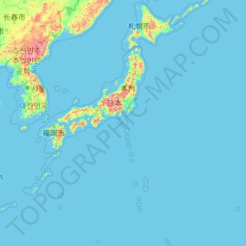
Name: Japan topographic map, elevation, terrain.
Location: Japan (20.21458 122.71418 45.71120 154.20554)
Average elevation: 58 m
Minimum elevation: -2 m
Maximum elevation: 2,683 m
Make a donation
Gear up for your next adventure:
As an Amazon Associate, this site earns from qualifying purchases at no extra cost to you.
Other topographic maps
Click on a map to view its topography, its elevation and its terrain.
Europe
Europe's topography is characterized by a striking contrast between its rugged southern mountains and the expansive plains of the north. The continent is often described as a "peninsula of peninsulas," featuring major peninsulas like the Iberian, Italian, and Balkan, each with unique geological features. In…
Average elevation: 223 m
Musandam
The rugged coastline resembles the glacier-carved coasts of polar regions, but in this case, the coast was shaped by the movement of Earth's crust. The Arabian Plate is slowly pushing under the Eurasian Plate, creating the earthquake-prone mountains of Iran. On the leading edge of the Arabian Plate, the…
Average elevation: 254 m
Make a donation
Gear up for your next adventure:
As an Amazon Associate, this site earns from qualifying purchases at no extra cost to you.
Make a donation
Gear up for your next adventure:
As an Amazon Associate, this site earns from qualifying purchases at no extra cost to you.
Make a donation
Gear up for your next adventure:
As an Amazon Associate, this site earns from qualifying purchases at no extra cost to you.
Tbilisi
Most of the raions are named after historic quarters of the city. The citizens of Tbilisi widely recognise an informal system of smaller historic neighbourhoods. Such neighbourhoods are several, however, constituting a kind of hierarchy, because most of them have lost their distinctive topographic limits. The…
Average elevation: 713 m
Make a donation
Gear up for your next adventure:
As an Amazon Associate, this site earns from qualifying purchases at no extra cost to you.
Sucre
Bolivia > Chuquisaca > Provincia Oropeza
Sucre (Spanish pronunciation: [ˈsukɾe]; Quechua: Chuqichaka; Aymara: Sukri; Guarani: Sucre), officially La Ilustre y Heroica Sucre ("The Illustrious and Heroic Sucre") is the de jure capital city of Bolivia, the capital of the Chuquisaca Department and the sixth most populous city in Bolivia. Located in the…
Average elevation: 2,829 m
Make a donation
Gear up for your next adventure:
As an Amazon Associate, this site earns from qualifying purchases at no extra cost to you.
Tewin Wood
United Kingdom > England > Hertfordshire > East Hertfordshire > Burnham Green
Average elevation: 101 m
Make a donation
Gear up for your next adventure:
As an Amazon Associate, this site earns from qualifying purchases at no extra cost to you.
Harare
Harare (/həˈrɑːreɪ/; formerly Salisbury /ˈsɔːlzbəri/) is the capital and most populous city of Zimbabwe. The city proper has an area of 940 km2 (371 mi2) and a population of 2.12 million in the 2012 census and an estimated 3.12 million in its metropolitan area in 2019. Situated in north-eastern…
Average elevation: 1,470 m
Paulpietersburg
South Africa > KwaZulu-Natal > Zululand District Municipality > eDumbe Local Municipality
Average elevation: 1,176 m
Pico de Orizaba
Mexico > Puebla > Chalchicomula de Sesma
Citlaltépetl (from Náhuatl citlal(in) = star, and tepētl = mountain), otherwise known as Pico de Orizaba, is an active volcano and the highest in North America, as well as the highest mountain in Mexico and third highest peak in North America, after Denali/Mount McKinley of the United States and Mount Logan…
Average elevation: 4,969 m
Make a donation
Gear up for your next adventure:
As an Amazon Associate, this site earns from qualifying purchases at no extra cost to you.
Make a donation
Gear up for your next adventure:
As an Amazon Associate, this site earns from qualifying purchases at no extra cost to you.
Make a donation
Gear up for your next adventure:
As an Amazon Associate, this site earns from qualifying purchases at no extra cost to you.
Ol Donyo Sabuk
Kenya > Machakos County > Matungulu > Matungulu North ward
The Fourteen Falls area is protected and equipped with a picnic site. as it has historical and religious importance both to the residents and Asian immigrants. The Asians use the site for recreation and spiritual rites, disposing of cremated ash in the river in the belief that it will go all the way to India…
Average elevation: 1,866 m
Make a donation
Gear up for your next adventure:
As an Amazon Associate, this site earns from qualifying purchases at no extra cost to you.
Limuru
Limuru encompasses areas previously known as the "white highlands," a rich agricultural land south of the equator. The term "white highlands" derived from the British and other Europeans who realised the productive potential of this area and settled in large numbers with the support of the colonial government,…
Average elevation: 2,254 m
Worcestershire Beacon
United Kingdom > England > Worcestershire > Malvern Hills
Average elevation: 197 m
Make a donation
Gear up for your next adventure:
As an Amazon Associate, this site earns from qualifying purchases at no extra cost to you.
Make a donation
Gear up for your next adventure:
As an Amazon Associate, this site earns from qualifying purchases at no extra cost to you.
Make a donation
Gear up for your next adventure:
As an Amazon Associate, this site earns from qualifying purchases at no extra cost to you.
Bruree
Ireland > County Limerick > The Municipal District of Cappamore — Kilmallock
Average elevation: 62 m
Romford
United Kingdom > England > Greater London
The town centre is about 50 feet (15 m) above sea level on a gravel terrace rising from the River Thames. The north of the town has developed on London Clay and is situated as much as 150 ft (46 m) above sea level. A continuous gentle rise in the eastern suburbs towards Gidea Park and Harold Wood peaks around…
Average elevation: 31 m
Make a donation
Gear up for your next adventure:
As an Amazon Associate, this site earns from qualifying purchases at no extra cost to you.
Watergrasshill
According to A Topographical Dictionary of Ireland, published by Samuel Lewis in 1837, Watergrasshill then had a population of 533 people.
Average elevation: 164 m
Make a donation
Gear up for your next adventure:
As an Amazon Associate, this site earns from qualifying purchases at no extra cost to you.
Grand Canyon
United States > Arizona > Coconino County
Uplift associated with mountain formation later moved these sediments thousands of feet upward and created the Colorado Plateau. The higher elevation has also resulted in greater precipitation in the Colorado River drainage area, but not enough to change the Grand Canyon area from being semi-arid. The uplift…
Average elevation: 1,023 m
Khorixas
Namibia > Kunene Region > Khorixas
The regional hospital and some other regional offices are located in Khorixas, though the capital of the Kunene Region is Opuwo. Khorixas has a landing strip nine kilometers east of town parallel to the C39 main road. The Runway Numbers are 09/27 and elevation is 3320 feet.
Average elevation: 974 m
Make a donation
Gear up for your next adventure:
As an Amazon Associate, this site earns from qualifying purchases at no extra cost to you.
Make a donation
Gear up for your next adventure:
As an Amazon Associate, this site earns from qualifying purchases at no extra cost to you.
Sugarlands
United States > Tennessee > Sevier County
In the 19the century, mountain areas became popular vacation destinations, especially since large urban areas were often wanting for clean air and scenery. Mineral-rich mountain springs were thought to have health-restoring qualities, and the cool air of the higher elevations lured people seeking relief from…
Average elevation: 607 m
Make a donation
Gear up for your next adventure:
As an Amazon Associate, this site earns from qualifying purchases at no extra cost to you.
Royton
Described in Samuel Lewis's A Topographical Dictionary of England (1848) as being in "aspect rather wild", Royton lies in a shallow valley amongst undulating land. The sources of the rivers Irk and Beal are to the northeast and east respectively. The Irk meanders southwesterly into Chadderton, and then onwards…
Average elevation: 181 m
Cape Coast
Ghana > Central Region > Cape Coast Metropolitan District
The city's topography is classified as hilly, the hills overlain by sandy silts. The rock type of the city is dominated by the Birimian formation and batholiths, also consisting of granite and pegmatite. There are valleys of various streams between the hills, with Kakum being the largest stream. The minor…
Average elevation: 22 m
Make a donation
Gear up for your next adventure:
As an Amazon Associate, this site earns from qualifying purchases at no extra cost to you.
Tagong
A gompa is where the Tagong Monastery is located. The gompa is one of the most important in the in Tibetan Pel Lhagong. The Tagong Monastery was established with reference to a nearby sacred mountain, Mt. Yala or Zhara Lhaste, which is 5,820 metres (19,090 ft) in elevation.
Average elevation: 3,874 m
Kovilpatti
India > Tamil Nadu > Kovilpatti
Kovilpatti is located in South India. It has an average elevation of 101 meters (334 ft).
Average elevation: 97 m
Make a donation
Gear up for your next adventure:
As an Amazon Associate, this site earns from qualifying purchases at no extra cost to you.
Lalitpur
Nepal > Bagamati Province > Lalitpur
Lalitpur (Nepali: ललितपुर) is a metropolitan city and fourth most populous city of Nepal with 299,843 inhabitants living in 77,159 households per the 2021 census. It is located in the south-central part of Kathmandu Valley, a large valley in the high plateaus in central Nepal, at an altitude of…
Average elevation: 1,608 m
Make a donation
Gear up for your next adventure:
As an Amazon Associate, this site earns from qualifying purchases at no extra cost to you.
Fort William
United Kingdom > Scotland > Highland
Fort William has an oceanic climate (Cfb) with moderate, but generally cool, temperatures and abundant precipitation. In the towns immediate vicinity, there are significant variations in elevation, which leads to some uninhabited areas near the town having a subpolar oceanic climate (Cfc), or, at the absolute…
Average elevation: 122 m
Make a donation
Gear up for your next adventure:
As an Amazon Associate, this site earns from qualifying purchases at no extra cost to you.
Mount Rohr
Canada > British Columbia > Squamish-Lillooet Regional District > Area B (Cayoosh/Pavilion)
Average elevation: 1,940 m
Rocca Calascio
At an elevation of around 1,460 metres (4,790 ft), the castle is the highest fortress in the Apennines. Built of stone and masonry exclusively for military purposes and intended only to accommodate troops and never as a residence for nobles, the fortress overlooks the Plain of Navelli at one of the highest…
Average elevation: 1,171 m
Edendale
South Africa > KwaZulu-Natal > uMgungundlovu District Municipality > Msunduzi Local Municipality
Average elevation: 809 m
Make a donation
Gear up for your next adventure:
As an Amazon Associate, this site earns from qualifying purchases at no extra cost to you.
Make a donation
Gear up for your next adventure:
As an Amazon Associate, this site earns from qualifying purchases at no extra cost to you.
Make a donation
Gear up for your next adventure:
As an Amazon Associate, this site earns from qualifying purchases at no extra cost to you.