
Michigan topographic map
Click on the map to display elevation.
Michigan
Michigan's topography is characterized by a diverse landscape that transitions from flat plains to rugged hills. The state comprises two peninsulas, with the Upper Peninsula showcasing more pronounced elevation changes, including its highest point, Mount Arvon, which rises to 1,979 feet (603 meters). In contrast, the Lower Peninsula features relatively flat terrain with some rolling hills, particularly in its southern regions. The average elevation across Michigan is around 862 feet (263 meters), and notable features include the Great Lakes, which greatly influence the state’s ecology and climate. Additionally, the landscape is marked by various lakes, rivers, and even significant sand dunes along the Lake Michigan shoreline, some reaching heights over 200 feet (61 meters). This unique blend of geographic features contributes to Michigan's rich natural beauty and ecological diversity.
About this map
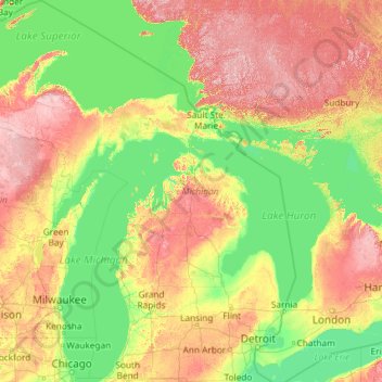
Name: Michigan topographic map, elevation, terrain.
Location: Michigan, United States (41.69613 -90.41862 48.30606 -82.12281)
Average elevation: 259 m
Minimum elevation: 169 m
Maximum elevation: 653 m
Other topographic maps
Click on a map to view its topography, its elevation and its terrain.
San Francisco Bay Area
United States > California > San Francisco
The San Francisco Bay Area is characterized by a diverse and dynamic topography shaped by geological processes over millions of years. This region features a combination of coastal plains, steep hills, and rugged mountains, all influenced by the tectonic activity associated with the nearby San Andreas Fault…
Average elevation: 113 m
Baltimore
United States > Maryland > Baltimore
Baltimore is in north-central Maryland on the Patapsco River close to where it empties into the Chesapeake Bay. The city is also located on the fall line between the Piedmont Plateau and the Atlantic coastal plain, which divides Baltimore into "lower city" and "upper city". The city's elevation ranges from sea…
Average elevation: 65 m
Appalachian Mountains
United States > North Carolina > Yancey County
The Appalachian Mountains (French: Appalaches), often called the Appalachians, are a system of mountains in eastern to northeastern North America. The Appalachians first formed roughly 480 million years ago during the Ordovician Period. They once reached elevations similar to those of the Alps and the Rocky…
Average elevation: 1,463 m
Scottsdale
United States > Arizona > Maricopa County > Scottsdale
The city is in the Salt River Valley, or the "Valley of the Sun," in the northern reaches of the Sonoran Desert. Scottsdale, 31 mi (50 km) long and 11.4 mi (18.3 km) wide at its widest point, shares boundaries with many other municipalities and entities. On the west, Scottsdale is bordered by Phoenix, Paradise…
Average elevation: 414 m
Columbus
United States > Ohio > Franklin County > Columbus
The confluence of the Scioto and Olentangy rivers is just north-west of Downtown Columbus. Several smaller tributaries course through the Columbus metropolitan area, including Alum Creek, Big Walnut Creek, and Darby Creek. Columbus is considered to have relatively flat topography thanks to a large glacier that…
Average elevation: 255 m
Santa Cruz Mountains
United States > California > Santa Clara County
The Santa Cruz Mountains are a region of great biological diversity, encompassing cool, moist coastal ecosystems as well as warm, dry chaparral. Much of the area in the Santa Cruz mountains is considered temperate rainforest. In valleys and moist ocean-facing slopes some of the southernmost coast redwoods…
Average elevation: 230 m
San Fernando Valley
United States > California > Los Angeles County > Los Angeles
Average elevation: 496 m
Rocky Mountains
United States > Wyoming > Teton County
Agriculture and forestry are major industries. Agriculture includes dryland and irrigated farming and livestock grazing. Livestock are frequently moved between high-elevation summer pastures and low-elevation winter pastures, a practice known as transhumance.
Average elevation: 2,292 m
Appalachian Mountains
United States > North Carolina > Yancey County
The Appalachian Mountains (French: Appalaches), often called the Appalachians, are a system of mountains in eastern to northeastern North America. The Appalachians first formed roughly 480 million years ago during the Ordovician Period. They once reached elevations similar to those of the Alps and the Rocky…
Average elevation: 1,463 m
Indianapolis
United States > Indiana > Indianapolis
Indianapolis is within the Tipton Till Plain, a flat to gently sloping terrain underlain by glacial deposits known as till. The lowest point in the city is about 650 feet (198 m) above mean sea level, with the highest natural elevation at about 900 feet (274 m) above sea level. Few hills or short ridges, known…
Average elevation: 241 m
Enchanted Rock
United States > Texas > Llano County
Enchanted Rock is a pink granite mountain located in the Llano Uplift about 17 miles (27 km) north of Fredericksburg, Texas and 24 miles (39 km) south of Llano, Texas, United States. Enchanted Rock State Natural Area, which includes Enchanted Rock and surrounding land, spans the border between Gillespie and…
Average elevation: 453 m
Navarre
United States > Florida > Santa Rosa County
Navarre is located at 30°24′04″N 86°51′47″W / 30.401°N 86.863°W / 30.401; -86.863Coordinates: 30°24′04″N 86°51′47″W / 30.401°N 86.863°W / 30.401; -86.863. It is located within a portion of the Florida Panhandle observing the Central Time Zone. Elevation is at an average of 10 feet (3.0 m).
Average elevation: 4 m
Evergreen
United States > Colorado > Jefferson County
Evergreen sits at an elevation of 7,220 feet (2,200 m) in the Rocky Mountains, 19 miles west of Denver, Colorado. Its addresses are oriented according to the Street_system_of_Denver.
Average elevation: 2,309 m
Sawtooth Range
United States > Idaho > Custer County
The Sawtooth Range is a mountain range of the Rocky Mountains in central Idaho, United States, reaching a maximum elevation of 10,751 feet (3,277 m) at the summit of Thompson Peak. It encompasses an area of 678 square miles (1,756 km2) spanning parts of Custer, Boise, Blaine, and Elmore counties, and is…
Average elevation: 2,761 m
Fogelsville
United States > Pennsylvania > Lehigh County > Upper Macungie Township
Average elevation: 155 m
Parrish
United States > Florida > Manatee County
Parrish features a predominantly flat terrain with an average elevation of approximately 36 feet above sea level. The area's landscape is characterized by gently rolling hills and low-lying regions, making it typical of the Central Florida topography. Surrounding Parrish are numerous wetlands and drainage…
Average elevation: 12 m
East Texas
United States > Pennsylvania > Lehigh County > Lower Macungie Township
Average elevation: 126 m
Englewood
United States > Florida > Sarasota County > Englewood
Englewood features predominantly flat and low-lying terrain typical of the region's coastal landscape. The average elevation here is approximately 15 feet above sea level, which makes the area particularly susceptible to tidal influences and storm surges. The terrain is interspersed with wetlands and…
Average elevation: 3 m
Lutz
United States > Florida > Hillsborough County > Tampa
Lutz is characterized by a gently rolling topography that showcases the distinctive features of the central Florida landscape. The area has an average elevation of about 70 feet (21 meters) above sea level, contributing to its mild undulations rather than dramatic elevation changes. The terrain is marked by a…
Average elevation: 20 m
Virginia Beach
United States > Virginia > Virginia Beach
According to the United States Census Bureau, the city has a total area of 497 square miles (1,290 km2), of which 249 square miles (640 km2) is land and 248 square miles (640 km2) (49.9%) is water. It is the largest city in Virginia by total area and third-largest city land area. The average elevation is 12…
Average elevation: 2 m
Kula
United States > Hawaii > Maui County
Kula is a district and census-designated place (CDP) of Maui, Hawaii, that stretches across the "up-country", the western-facing slopes of Haleakalā, from Makawao to Kanaio. Most of the residential areas lie between about 500 to 1,100 m (1,600 to 3,600 ft) in elevation. The district has traditionally been…
Average elevation: 740 m
McKinleyville
United States > California > Humboldt County
McKinleyville (formerly Minorsville) is a census-designated place (CDP) in Humboldt County, California McKinleyville is located 5.25 miles (8.4 km) north of Arcata, at an elevation of 141 feet (43 m). The population was 15,177 at the 2010 census, up from 13,599 at the time of the 2000 census.
Average elevation: 49 m
Arden
United States > North Carolina > Buncombe County > Asheville > Royal Pines
Average elevation: 693 m
Ruby Mountains
United States > Nevada > Elko County
The Ruby Mountains (Shoshoni: 'Duka Doya', meaning “Snowcapped”) are a mountain range, primarily located within Elko County with a small extension into White Pine County, in Nevada, United States. Most of the range is included within the Humboldt-Toiyabe National Forest. The range reaches a maximum…
Average elevation: 1,962 m
Denali
United States > Alaska > Denali Borough
Denali (/dəˈnɑːli/ də-NAH-lee), federally designated as Mount McKinley, is the highest mountain peak in North America, with a summit elevation of 20,310 feet (6,190 m) above sea level. It is the tallest mountain in the world from base to peak on land, measuring 18,000 ft (5,500 m). With a topographic…
Average elevation: 5,546 m
Palm Harbor
United States > Florida > Pinellas County
Palm Harbor is characterized by its unique topography, which features a relatively rare hilly landscape for the region. Unlike much of the surrounding areas in Pinellas County, which are predominantly flat, Palm Harbor includes elevations that can reach up to about 75 feet above sea level. This elevation gives…
Average elevation: 9 m
Dingmans Ferry
United States > Pennsylvania > Pike County > Delaware Township
Average elevation: 192 m
Southfield
United States > Massachusetts > Berkshire County > New Marlborough
Average elevation: 405 m
Camelback Mountain
United States > Arizona > Maricopa County > Phoenix
Efforts to protect Camelback Mountain as a natural preserve began in the early 1910s. However, by the 1960s, nearly all of the area had been sold to private interests. Federal and state authorities attempted to stop development above the one thousand and six hundred feet level. They failed to halt development…
Average elevation: 463 m
South Gulf Cove Park
United States > Florida > Charlotte County > Port Charlotte
Average elevation: 3 m
Wheeler Peak
United States > New Mexico > Taos County
Wheeler Peak is the highest natural point in the U.S. state of New Mexico. It is located northeast of Taos and south of Red River in the northern part of the state, and just 2 miles (3.2 km) southeast of the ski slopes of Taos Ski Valley. It lies in the Sangre de Cristo Mountains, the southernmost subrange of…
Average elevation: 3,674 m
Silvermine
United States > Connecticut > Western Connecticut Planning Region > Norwalk
Average elevation: 66 m
Lower Ninth Ward
United States > Louisiana > Orleans Parish > New Orleans
The most severely damaged section of the Ward was the lower elevation section, north of Claiborne Avenue. A Bring Back New Orleans Commission preliminary report suggested making this area in whole or part into park space because of the high risk of future flooding. Most Lower 9th Ward residents have strongly…
Average elevation: 1 m
Little Saint James Island
United States > United States Virgin Islands > Saint Thomas - Saint John District
Average elevation: 1 m
Palmetto Dunes
United States > South Carolina > Beaufort County > Hilton Head Island
Average elevation: 3 m
El Dorado Hills
United States > California > El Dorado County > Cameron Park
El Dorado Hills (EDH), as defined by the 2010 census-designated place (CDP), is at the western border of El Dorado County, between the City of Folsom and the unincorporated community of Cameron Park. The northern limits of the CDP are Folsom Lake and the South Fork of the American River, where river rafters…
Average elevation: 254 m
No Name Pond
United States > Maine > Somerset County > Bald Mountain Township T4 R3
Average elevation: 686 m
Murphys
United States > California > Calaveras County
"MURPHY'S CAMP is a curious old mining-town in Calaveras County, at an elevation of 2,400 feet (730 m) above the sea, situated like a nest in the center of a rough, gravelly region, rich in gold. Granites, slates, lavas, limestone, iron ores, quartz veins, auriferous gravels, remnants of dead fire-rivers and…
Average elevation: 702 m
Ouray
United States > Colorado > Ouray County
Ouray (/ˈjʊəreɪ/ YOOR-ay) is a home rule municipality that is the county seat of Ouray County, Colorado, United States. The city population was 898 as of the 2020 census. The Ouray Post Office has the ZIP Code 81427. Located at an elevation of 7,792 feet (2,375 m), Ouray's climate, natural alpine…
Average elevation: 2,717 m
Wesley Chapel
United States > Florida > Pasco County
According to the United States Census Bureau, the CDP has a total area of 6.1 square miles (16 km2), of which 6.1 square miles (16 km2) is land and 0.04 square miles (0.10 km2) (0.49%) is water. The elevation is about 100 feet (30 m), combined with an inland location, creates more temperature variation in the…
Average elevation: 19 m