
Portugal topographic map
Interactive map
Click on the map to display elevation.
Portugal
Portugal's topography is a diverse tapestry of rugged mountains, rolling plains, and extensive coastlines. In the north, the landscape is predominantly mountainous, with the Serra da Estrela range featuring Torre, the highest peak on mainland Portugal at 1,993 meters. This region is characterized by steep slopes and deep valleys carved by rivers such as the Douro and Mondego. Moving southward, the terrain transitions into the undulating plains of the Alentejo, marked by gentle hills and expansive agricultural fields. The southernmost region, the Algarve, boasts a varied landscape of limestone caves, grottoes, and sandy beaches along its coastline. Portugal's extensive Atlantic coastline stretches over 1,700 kilometers, featuring a mix of rugged cliffs and sandy shores. Additionally, the archipelagos of Madeira and the Azores, both autonomous regions of Portugal, are known for their volcanic origins, resulting in dramatic landscapes of craters, lakes, and lush vegetation.
About this map
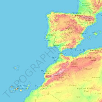
Name: Portugal topographic map, elevation, terrain.
Location: Portugal (29.82825 -31.55753 42.15431 -6.18916)
Average elevation: 268 m
Minimum elevation: -2 m
Maximum elevation: 3,622 m
Other topographic maps
Click on a map to view its topography, its elevation and its terrain.
Tbilisi
Most of the raions are named after historic quarters of the city. The citizens of Tbilisi widely recognise an informal system of smaller historic neighbourhoods. Such neighbourhoods are several, however, constituting a kind of hierarchy, because most of them have lost their distinctive topographic limits. The…
Average elevation: 713 m
Harare
Harare (/həˈrɑːreɪ/; formerly Salisbury /ˈsɔːlzbəri/) is the capital and most populous city of Zimbabwe. The city proper has an area of 940 km2 (371 mi2) and a population of 2.12 million in the 2012 census and an estimated 3.12 million in its metropolitan area in 2019. Situated in north-eastern…
Average elevation: 1,470 m
Quabbs Plantation
United Kingdom > England > Shropshire > Westbury > Vron Gate
Average elevation: 228 m
Knighton
United Kingdom > Wales > Powys
The town became a borough in 1203, with a charter permitting a weekly market and annual fair. The presence of two castles within a comparatively small town suggests that one (the earlier motte and bailey sited atop the town) went out of use before the establishment of the second (the motte with no bailey at…
Average elevation: 295 m
Europe
Europe's topography is characterized by a striking contrast between its rugged southern mountains and the expansive plains of the north. The continent is often described as a "peninsula of peninsulas," featuring major peninsulas like the Iberian, Italian, and Balkan, each with unique geological features. In…
Average elevation: 223 m
Ngorongoro Conservation Area
The southern and eastern boundaries of the Serengeti ecosystem are approximately defined by the rim of the East African Rift wall, which also prevents animal migration in these directions. In the topographical map, Lake Nyanza is the same as Lake Victoria in the Serengeti Ecosystem map.
Average elevation: 1,604 m
Dilla
Ethiopia > South Ethiopia Regional State
Dilla (Amharic: ዲላ) is a market town and separate woreda in southern Ethiopia. The administrative center of the Gedeo Zone in the former Southern Nations, Nationalities, and Peoples Region (SNNPR) now it is South Ethiopia Regional State (SER), it is located on the main road from Addis Ababa to Nairobi. The…
Average elevation: 1,886 m
Kalaw
Myanmar > Shan State > Kalaw District
The hill station is located at an elevation of 1310 metres, 50 km from the Inle lake. Kalaw is famous for hiking and trekking. Many trekking trails ranging from nearby places to Inle Lake and Pindaya. The town still feels like a high-altitude holiday resort – the air is cool, the atmosphere is calm and the…
Average elevation: 1,366 m
Derry/Londonderry
United Kingdom > Northern Ireland > County Londonderry
Derry is characterised by its distinctively hilly topography. The River Foyle forms a deep valley as it flows through the city, giving it a steep topography. The original walled city of Londonderry lies on a hill on the west bank of the River Foyle. In the past, the river branched and enclosed this hill as an…
Average elevation: 88 m
Taunggyi
Myanmar > Shan State > Taunggyi District
Taunggyi (Burmese: တောင်ကြီးမြို့, MLCTS: taung kri: mrui. [tàʊɰ̃dʑí mjo̰]) is the capital and largest city of Shan State, Myanmar (Burma); and lies on the Thazi-Kyaingtong road at an elevation of 4,712 feet (1,436 m), just north of Shwenyaung and Inle Lake within the Myelat…
Average elevation: 1,151 m
East London
South Africa > Eastern Cape > Buffalo City Metropolitan Municipality
Average elevation: 72 m
Indian Ocean
Average elevation: 0 m
Bruff
Ireland > County Limerick > The Municipal District of Cappamore — Kilmallock
Average elevation: 68 m
Subotica
Serbia > Vojvodina > North Backa Administrative District
It is located in Central Europe at the Pannonian Basin at 46.07° North, 19.68° East, at the altitude of 109m, about 10 kilometres (6 miles) from the border with Hungary, and is the northernmost city in Serbia. Lake Palić is in the immediate vicinity of the city. Sand dunes area Subotička Peščara is…
Average elevation: 115 m
Palmerston North
New Zealand > Manawatu-Whanganui > Palmerston North City
Although the land Palmerston North is situated on is bounded by the lofty Ruahine and Tararua ranges in the east and south respectively, the city has a predominantly flat appearance. The occasional rise in elevation occurs further away from the river and is especially pronounced in the north and northeast, and…
Average elevation: 118 m
Foxfield Park
United States > California > Los Angeles County > Westlake Village
Average elevation: 301 m