
Moree Plains Shire Council topographic map
Interactive map
Click on the map to display elevation.
About this map
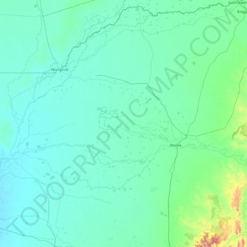
Name: Moree Plains Shire Council topographic map, elevation, terrain.
Location: Moree Plains Shire Council, Australia (-30.10547 148.67615 -28.53718 150.48613)
Average elevation: 204 m
Minimum elevation: 143 m
Maximum elevation: 1,185 m
Other topographic maps
Click on a map to view its topography, its elevation and its terrain.
Picnic Point
Australia > Queensland > Toowoomba
The first addition to the Picnic Point Reserve was made when the Municipal Council purchased two freehold allotments fronting both Heller and Rowbotham Streets in 1902. By 1906 the council had commenced tree-planting at Picnic Point under the supervision of Curator Harding of the Botanical gardens. A further…
Average elevation: 575 m
Dandenong Ranges
Australia > Victoria > Melbourne
The topography consists of a series of ridges dissected by deeply cut streams. Sheltered gullies in the south of the range are home to temperate rain forest, fern gullies and Mountain Ash forest Eucalyptus regnans, whereas the drier ridges and exposed northern slopes are covered by dry sclerophyll forest of…
Average elevation: 456 m
Blue Mountains
A sandstone plateau dominated by a landscape of eucalyptus forests, the Blue Mountains are located at the top of a 470-million-year-old quartzite. In the Permian period, a shallow sea covered the region, when rivers brought shales, siltstones and mudstones. Then during the Mesozoic period, rivers dumped vast…
Average elevation: 566 m
Ballarat
Ballarat has a moderate oceanic climate (Köppen climate classification Cfb) with four distinct seasons. Its elevation, ranging between 400 and 630 metres (1,310 and 2,070 feet) above sea level, causes its mean monthly temperatures to tend to be on average 3 to 5 °C (5 to 9 °F) below those of Melbourne,…
Average elevation: 470 m
Forster Lookout
Australia > South Australia > Mid Murray Council > Nildottie > Forster
Average elevation: 39 m
Mount Kembla
Australia > New South Wales > Wollongong
The summit of Mount Kembla has an elevation of 534 metres (1,752 ft) above sea level.
Average elevation: 227 m