
Dandenong Ranges topographic map
Click on the map to display elevation.
Dandenong Ranges
The topography consists of a series of ridges dissected by deeply cut streams. Sheltered gullies in the south of the range are home to temperate rain forest, fern gullies and Mountain Ash forest Eucalyptus regnans, whereas the drier ridges and exposed northern slopes are covered by dry sclerophyll forest of stringybarks and box. The entire range is highly prone to bushfires, the most recent of which have been the 1983 Ash Wednesday bushfires, the 1997 Dandenong Ranges bushfires and small fires during the Black Saturday bushfires in 2009.
About this map
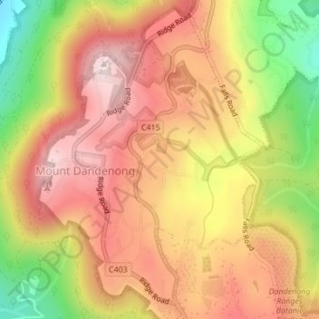
Name: Dandenong Ranges topographic map, elevation, terrain.
Average elevation: 456 m
Minimum elevation: 213 m
Maximum elevation: 621 m
Other topographic maps
Click on a map to view its topography, its elevation and its terrain.
Mount Dandenong
Australia > Victoria > Melbourne
Mount Dandenong has an oceanic climate (Cfb) with warm summers and cool winters. The temperature usually is 3 - 7 °C (5.4 - 12.6 °F) cooler than downtown Melbourne due to its elevation and distance from the urban island heating effect of Melbourne.
Average elevation: 389 m