Geolocate

Kalorama topographic map

Click on the map to display elevation.

About this map
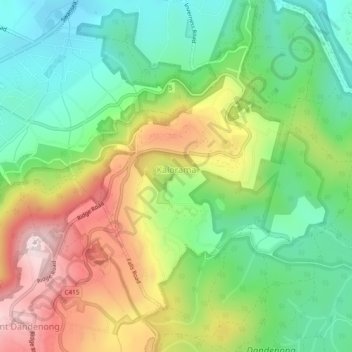
Name: Kalorama topographic map, elevation, terrain.

Location: Kalorama, Melbourne, Shire of Yarra Ranges, Victoria, 3766, Australia (-37.83410 145.35725 -37.80612 145.40496)

Average elevation: 331 m

Minimum elevation: 141 m

Maximum elevation: 621 m

Other topographic maps

Click on a map to view its topography, its elevation and its terrain.
Dandenong Ranges

Australia > Victoria > Melbourne

The topography consists of a series of ridges dissected by deeply cut streams. Sheltered gullies in the south of the range are home to temperate rain forest, fern gullies and Mountain Ash forest Eucalyptus regnans, whereas the drier ridges and exposed northern slopes are covered by dry sclerophyll forest of…

Average elevation: 456 m
Brimbank Park

Australia > Victoria > Melbourne

Average elevation: 52 m

Woodvale Park

Australia > Victoria > Melbourne

Average elevation: 110 m

Gear up for your next adventure:

🧺Waterproof Picnic Blankets - Dry seating for breaks on damp grass
🛠️Tent Repair Kits - Fix tents on the trail
⛺Emergency Bivvy Bags - Life-saving heat-reflective shelter for emergencies
🌄Sun Protection Gear - Gear to shield from strong sun
🎁Outdoor Gift Ideas - Great gifts for adventurers

As an Amazon Associate, this site earns from qualifying purchases at no extra cost to you.