
Albania topographic map
Interactive map
Click on the map to display elevation.
Albania
The climate in the country is extremely variable and diverse owing to the differences in latitude, longitude and altitude. Albania experiences predominantly a mediterranean and continental climate, with four distinct seasons. Defined by the Köppen classification, it accommodates five major climatic types ranging from mediterranean and subtropical in the western half to oceanic, continental and subarctic in the eastern half of Albania.
About this map
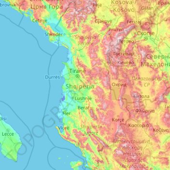
Name: Albania topographic map, elevation, terrain.
Location: Albania (39.64039 19.00099 42.66108 21.05743)
Average elevation: 522 m
Minimum elevation: -7 m
Maximum elevation: 2,633 m
Other topographic maps
Click on a map to view its topography, its elevation and its terrain.
Tbilisi
Most of the raions are named after historic quarters of the city. The citizens of Tbilisi widely recognise an informal system of smaller historic neighbourhoods. Such neighbourhoods are several, however, constituting a kind of hierarchy, because most of them have lost their distinctive topographic limits. The…
Average elevation: 713 m
Europe
Europe's topography is characterized by a striking contrast between its rugged southern mountains and the expansive plains of the north. The continent is often described as a "peninsula of peninsulas," featuring major peninsulas like the Iberian, Italian, and Balkan, each with unique geological features. In…
Average elevation: 223 m
Dilla
Ethiopia > South Ethiopia Regional State
Dilla (Amharic: ዲላ) is a market town and separate woreda in southern Ethiopia. The administrative center of the Gedeo Zone in the former Southern Nations, Nationalities, and Peoples Region (SNNPR) now it is South Ethiopia Regional State (SER), it is located on the main road from Addis Ababa to Nairobi. The…
Average elevation: 1,886 m
Quabbs Plantation
United Kingdom > England > Shropshire > Westbury > Vron Gate
Average elevation: 228 m
Brandon Hill
Brandon Hill (Irish: Cnoc Bhréanail) is the highest mountain in County Kilkenny, Ireland, with an elevation of 515 m (1,690 ft) and prominence at 448 m (1,470 ft). The South Leinster Way, a long-distance trail, meandering through the Barrow Valley and traverses Brandon Hill. The village of Graiguenamanagh and…
Average elevation: 294 m
Grabouw
South Africa > Western Cape > Theewaterskloof Local Municipality
The Elgin valley is South Africa's coolest climate wine-growing region and a range of other geographic factors (for example, its proximity to the Atlantic Ocean, cool temperatures, plentiful winter rainfall, prevailing wind directions, and altitude) have created a set of conditions for wine growing which are…
Average elevation: 358 m
Harare
Harare (/həˈrɑːreɪ/; formerly Salisbury /ˈsɔːlzbəri/) is the capital and most populous city of Zimbabwe. The city proper has an area of 940 km2 (371 mi2) and a population of 2.12 million in the 2012 census and an estimated 3.12 million in its metropolitan area in 2019. Situated in north-eastern…
Average elevation: 1,470 m
Knighton
United Kingdom > Wales > Powys
The town became a borough in 1203, with a charter permitting a weekly market and annual fair. The presence of two castles within a comparatively small town suggests that one (the earlier motte and bailey sited atop the town) went out of use before the establishment of the second (the motte with no bailey at…
Average elevation: 295 m
Ngorongoro Conservation Area
The southern and eastern boundaries of the Serengeti ecosystem are approximately defined by the rim of the East African Rift wall, which also prevents animal migration in these directions. In the topographical map, Lake Nyanza is the same as Lake Victoria in the Serengeti Ecosystem map.
Average elevation: 1,604 m
Kalaw
Myanmar > Shan State > Kalaw District
The hill station is located at an elevation of 1310 metres, 50 km from the Inle lake. Kalaw is famous for hiking and trekking. Many trekking trails ranging from nearby places to Inle Lake and Pindaya. The town still feels like a high-altitude holiday resort – the air is cool, the atmosphere is calm and the…
Average elevation: 1,366 m
Derry/Londonderry
United Kingdom > Northern Ireland > County Londonderry
Derry is characterised by its distinctively hilly topography. The River Foyle forms a deep valley as it flows through the city, giving it a steep topography. The original walled city of Londonderry lies on a hill on the west bank of the River Foyle. In the past, the river branched and enclosed this hill as an…
Average elevation: 88 m
Taunggyi
Myanmar > Shan State > Taunggyi District
Taunggyi (Burmese: တောင်ကြီးမြို့, MLCTS: taung kri: mrui. [tàʊɰ̃dʑí mjo̰]) is the capital and largest city of Shan State, Myanmar (Burma); and lies on the Thazi-Kyaingtong road at an elevation of 4,712 feet (1,436 m), just north of Shwenyaung and Inle Lake within the Myelat…
Average elevation: 1,151 m
East London
South Africa > Eastern Cape > Buffalo City Metropolitan Municipality
Average elevation: 72 m