
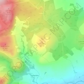
Y Lordship topographic map
Interactive map
Click on the map to display elevation.
About this map
Name: Y Lordship topographic map, elevation, terrain.
Location: Y Lordship, Gwynedd, Wales, LL23 7TD, United Kingdom (52.87583 -3.70237 52.87593 -3.70227)
Average elevation: 278 m
Minimum elevation: 166 m
Maximum elevation: 431 m
Other topographic maps
Click on a map to view its topography, its elevation and its terrain.
Brecon Beacons National Park
United Kingdom > Wales > Powys
Brecon Beacons National Park, officially named Bannau Brycheiniog National Park (Welsh pronunciation), is a national park in Wales. It is named after the Brecon Beacons (Welsh: Bannau Brycheiniog), the mountain range at its centre. The national park includes the highest mountain in South Wales, Pen y Fan,…
Average elevation: 270 m
Milford Haven
United Kingdom > Wales > Pembrokeshire
One of the earliest notable figures from the Milford Haven area is Howell Davis, a pirate born in 1680. He was shot dead in 1719 on the Portuguese island of Príncipe. Other famous residents connected as seafarers include Isaac Davis, a former seaman who was engaged in the fur trade between the Pacific…
Average elevation: 36 m