
North Island topographic map
Interactive map
Click on the map to display elevation.
About this map
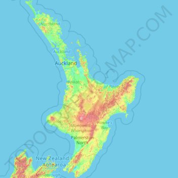
Name: North Island topographic map, elevation, terrain.
Location: North Island, New Zealand (-41.61375 172.64302 -34.39339 178.55050)
Average elevation: 66 m
Minimum elevation: -1 m
Maximum elevation: 2,650 m
Other topographic maps
Click on a map to view its topography, its elevation and its terrain.
Oban
New Zealand > Southland > Southland District > Stewart Island / Rakiura Community
Average elevation: 23 m
Mount Aspiring
New Zealand > West Coast > Westland District
Mount Aspiring / Tititea is New Zealand's 23rd-highest mountain. The peak's altitude of 3,033 metres (9,951 ft) makes it the country's highest outside the Aoraki / Mount Cook region.
Average elevation: 2,257 m
Wellington
New Zealand > Wellington > Wellington City
Averaging 2,055 hours of sunshine per year, the climate of Wellington is temperate marine, (Köppen: Cfb), generally moderate all year round with warm summers and mild winters, and rarely sees temperatures above 26 °C (79 °F) or below 4 °C (39 °F). The hottest recorded temperature in the city is 31.1 °C…
Average elevation: 85 m
Motuarohia Island (Roberton Island)
New Zealand > Bay of Islands-Whangaroa Community
Average elevation: 1 m
Greymouth
New Zealand > West Coast > Grey District > Greymouth
A combination of high intensity rainfall, high topographic relief and short steep rivers often leads to rapid flooding of low-lying land across the West Coast. Since its founding Greymouth has experienced two dozen floods by the Grey River, with many of the most significant being assigned names: for example,…
Average elevation: 40 m