
Make a donation
Gear up for your next adventure:
As an Amazon Associate, this site earns from qualifying purchases at no extra cost to you.
Mount Aspiring topographic map
Click on the map to display elevation.
Make a donation
Gear up for your next adventure:
As an Amazon Associate, this site earns from qualifying purchases at no extra cost to you.
Mount Aspiring
Mount Aspiring / Tititea is New Zealand's 23rd-highest mountain. The peak's altitude of 3,033 metres (9,951 ft) makes it the country's highest outside the Aoraki / Mount Cook region.
Make a donation
Gear up for your next adventure:
As an Amazon Associate, this site earns from qualifying purchases at no extra cost to you.
About this map
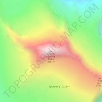
Name: Mount Aspiring topographic map, elevation, terrain.
Location: Mount Aspiring, Westland District, West Coast, New Zealand (-44.38421 168.72791 -44.38411 168.72801)
Average elevation: 2,257 m
Minimum elevation: 1,635 m
Maximum elevation: 2,991 m
Make a donation
Gear up for your next adventure:
As an Amazon Associate, this site earns from qualifying purchases at no extra cost to you.