
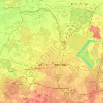
Cottbus - Chóśebuz topographic map
Interactive map
Click on the map to display elevation.
About this map
Name: Cottbus - Chóśebuz topographic map, elevation, terrain.
Location: Cottbus - Chóśebuz, Brandenburg, Germany (51.69257 14.27329 51.86422 14.50129)
Average elevation: 69 m
Minimum elevation: 25 m
Maximum elevation: 113 m
Other topographic maps
Click on a map to view its topography, its elevation and its terrain.
Naundorf - Glinsk
Germany > Brandenburg > Spree-Neiße - Sprjewja-Nysa > Forst (Lausitz) - Baršć
Naundorf - Glinsk, Forst (Lausitz) - Baršć, Spree-Neiße - Sprjewja-Nysa, Brandenburg, Germany
Average elevation: 69 m
Schönwalde-Glien
Germany > Brandenburg > Havelland
Schönwalde-Glien, Havelland, Brandenburg, 14621, Germany
Average elevation: 39 m
Oderberg
Germany > Brandenburg > Barnim
Oderberg, Britz-Chorin-Oderberg, Barnim, Brandenburg, 16248, Germany
Average elevation: 37 m
Falkenberg/Elster
Germany > Brandenburg > Falkenberg/Elster
Falkenberg/Elster, Elbe-Elster, Brandenburg, 04895, Germany
Average elevation: 86 m
D 67
Germany > Brandenburg > Neuhausen/Spree
D 67, Neuhausen/Spree, Spree-Neiße, Brandenburg, 03051, Germany
Average elevation: 92 m
Cottbus - Chóśebuz
Germany > Brandenburg > Cottbus - Chóśebuz
Cottbus, Cottbus - Chóśebuz, Brandenburg, 03046, Germany
Average elevation: 79 m
Schönewalde
Germany > Brandenburg > Schönewalde
Schönewalde, Elbe-Elster, Brandenburg, Germany
Average elevation: 86 m
Alt Tucheband
Germany > Brandenburg > Alt Tucheband
Alt Tucheband, Golzow, Märkisch-Oderland, Brandenburg, Germany
Average elevation: 14 m
D 21
Germany > Brandenburg > Neuhausen/Spree
D 21, Neuhausen/Spree, Spree-Neiße, Brandenburg, 03058, Germany
Average elevation: 93 m
D 45
Germany > Brandenburg > Neuhausen/Spree
D 45, Neuhausen/Spree, Spree-Neiße, Brandenburg, Germany
Average elevation: 99 m
D 25
Germany > Brandenburg > Kolkwitz
D 25, Kolkwitz, Spree-Neiße, Brandenburg, 03099, Germany
Average elevation: 68 m