
Steinbach an der Steyr topographic map
Interactive map
Click on the map to display elevation.
About this map
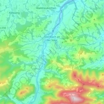
Name: Steinbach an der Steyr topographic map, elevation, terrain.
Location: Steinbach an der Steyr, Bezirk Kirchdorf, 4596, Österreich (47.91202 14.24774 48.00322 14.31729)
Average elevation: 543 m
Minimum elevation: 328 m
Maximum elevation: 1,256 m
Steinbach an der Steyr liegt auf 381 m Höhe im Traunviertel im Steyrtal etwa 20 km von der Stadt Steyr entfernt. Die Ausdehnung beträgt von Nord nach Süd 10,2 km und von West nach Ost 5,2 km. Die Gesamtfläche beträgt 28,3 km², 36,0 % der Fläche sind bewaldet und 53,7 % der Fläche sind landwirtschaftlich genutzt. In der Nähe der höchsten Erhebung der Gemeinde, des Hochbuchbergs (1273 m), befindet sich die Grünburger Hütte (1080 m).
Other topographic maps
Click on a map to view its topography, its elevation and its terrain.
Pettenbach
Pettenbach, Bezirk Kirchdorf, 4643, Österreich
Average elevation: 518 m
Wartberg an der Krems
Wartberg an der Krems, Bezirk Kirchdorf, 4552, Österreich
Average elevation: 462 m
Edlbach
Edlbach, Bezirk Kirchdorf, 4580, Österreich
Average elevation: 675 m
Spital am Pyhrn
Spital am Pyhrn, Bezirk Kirchdorf, 4582, Österreich
Average elevation: 1,106 m
Windischgarsten
Windischgarsten, Bezirk Kirchdorf, 4580, Österreich
Average elevation: 660 m
Großer Priel
Österreich > Bezirk Kirchdorf > Hinterstoder
Großer Priel, Hinterstoder, Bezirk Kirchdorf, 4573, Österreich
Average elevation: 1,919 m