
Spital am Pyhrn topographic map
Interactive map
Click on the map to display elevation.
About this map
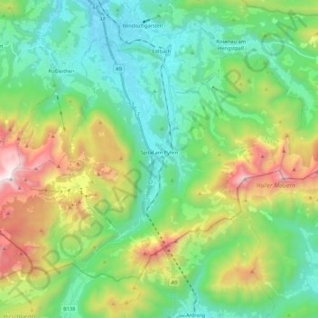
Name: Spital am Pyhrn topographic map, elevation, terrain.
Location: Spital am Pyhrn, Bezirk Kirchdorf, 4582, Österreich (47.60636 14.22310 47.71680 14.43601)
Average elevation: 1,106 m
Minimum elevation: 571 m
Maximum elevation: 2,367 m
Spital am Pyhrn liegt auf 640 m Seehöhe im Traunviertel. Die Ausdehnung beträgt von Nord nach Süd 16 und von West nach Ost 12,3 Kilometer. Die Gesamtfläche der Gemeinde umfasst 108,89 Quadratkilometer. Davon sind 63 Prozent bewaldet und 15 Prozent werden landwirtschaftlich genutzt.
Other topographic maps
Click on a map to view its topography, its elevation and its terrain.
Pettenbach
Pettenbach, Bezirk Kirchdorf, 4643, Österreich
Average elevation: 518 m
Wartberg an der Krems
Wartberg an der Krems, Bezirk Kirchdorf, 4552, Österreich
Average elevation: 462 m
Edlbach
Edlbach, Bezirk Kirchdorf, 4580, Österreich
Average elevation: 675 m
Windischgarsten
Windischgarsten, Bezirk Kirchdorf, 4580, Österreich
Average elevation: 660 m
Großer Priel
Österreich > Bezirk Kirchdorf > Hinterstoder
Großer Priel, Hinterstoder, Bezirk Kirchdorf, 4573, Österreich
Average elevation: 1,919 m
Steinbach an der Steyr
Steinbach an der Steyr, Bezirk Kirchdorf, 4596, Österreich
Average elevation: 543 m