
Edlbach topographic map
Interactive map
Click on the map to display elevation.
About this map
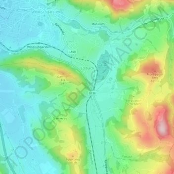
Name: Edlbach topographic map, elevation, terrain.
Location: Edlbach, Bezirk Kirchdorf, 4580, Österreich (47.69136 14.33256 47.72138 14.38551)
Average elevation: 675 m
Minimum elevation: 586 m
Maximum elevation: 887 m
Edlbach liegt auf 770 m Höhe im Traunviertel. Die Ausdehnung beträgt von Nord nach Süd 4 km und von West nach Ost 3,4 km. Die Gesamtfläche beträgt 8,3 km². 24,1 % der Fläche sind bewaldet und 65,1 % der Fläche sind landwirtschaftlich genutzt.
Other topographic maps
Click on a map to view its topography, its elevation and its terrain.
Pettenbach
Pettenbach, Bezirk Kirchdorf, 4643, Österreich
Average elevation: 518 m
Wartberg an der Krems
Wartberg an der Krems, Bezirk Kirchdorf, 4552, Österreich
Average elevation: 462 m
Spital am Pyhrn
Spital am Pyhrn, Bezirk Kirchdorf, 4582, Österreich
Average elevation: 1,106 m
Windischgarsten
Windischgarsten, Bezirk Kirchdorf, 4580, Österreich
Average elevation: 660 m
Großer Priel
Österreich > Bezirk Kirchdorf > Hinterstoder
Großer Priel, Hinterstoder, Bezirk Kirchdorf, 4573, Österreich
Average elevation: 1,919 m
Steinbach an der Steyr
Steinbach an der Steyr, Bezirk Kirchdorf, 4596, Österreich
Average elevation: 543 m