
Northern Province topographic map
Interactive map
Click on the map to display elevation.
About this map
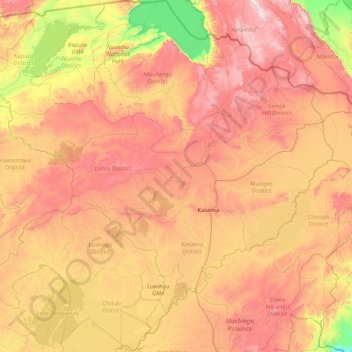
Name: Northern Province topographic map, elevation, terrain.
Location: Northern Province, Zambia (-11.50644 29.08006 -8.27493 32.35639)
Average elevation: 1,289 m
Minimum elevation: 691 m
Maximum elevation: 2,207 m
The Northern Province lies mainly on the great southern African plateau which has been uplifted to an elevation around 1200 metres above sea level. Rift valleys extend clockwise around the province from the north-west to the south. These rift valleys are sometimes outside the borders of the province, as in the case of the Luapula-Mweru valley to the north-west and the Lake Rukwa and Lake Malawi rift valleys to the north east; but the escarpments of the Lake Mweru-wa-Ntipa-Lake Tanganyika rifts in the north, and the Luangwa Valley rift in the east and south-east are just within the province. In places the rift valleys have pushed up highlands: around Kambole and Mbala above Lake Tanganyika, (the Muchinga escarpment above the Luangwa valley, and the highlands along north-eastern border with Tanzania and Malawi which culminate in the Mafinga Hills and Nyika Plateau. These are now in Muchinga Province)
Other topographic maps
Click on a map to view its topography, its elevation and its terrain.
Mufumbwe District
Zambia > North-Western Province, Zambia
Mufumbwe District, North-Western Province, Zambia, Zambia
Average elevation: 1,172 m
Kasempa
Zambia > North-Western Province, Zambia > Kasempa
Kasempa, Kasempa District, North-Western Province, Zambia, Zambia
Average elevation: 1,251 m
South Luangwa National Park
South Luangwa National Park, Muchinga Province, Zambia
Average elevation: 854 m
Victoria Falls
Zambia > Southern Province > Livingstone
Victoria Falls, Livingstone, Southern Province, Zambia
Average elevation: 875 m
Lusaka
Zambia > Lusaka Province > Lusaka
Lusaka, Lusaka District, Lusaka Province, 10101, Zambia
Average elevation: 1,227 m
Chinsali
Zambia > Muchinga Province > Chinsali
Chinsali, Muchinga Province, Zambia
Average elevation: 1,294 m
Siavonga
Zambia > Southern Province > Siavonga
Siavonga, Southern Province, Zambia
Average elevation: 514 m