
Lusaka Province topographic map
Interactive map
Click on the map to display elevation.
About this map
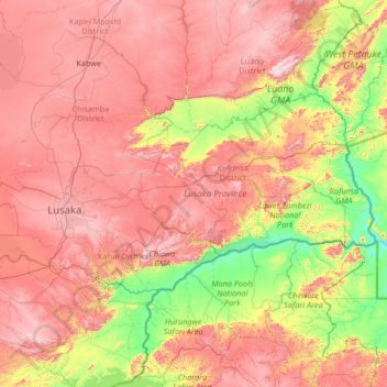
Name: Lusaka Province topographic map, elevation, terrain.
Location: Lusaka Province, Zambia (-15.97010 27.76911 -14.64314 30.42080)
Average elevation: 866 m
Minimum elevation: 325 m
Maximum elevation: 1,604 m
Lusaka Province is bordered along Zimbabwe along Lower Zambezi National Park in the south, Central Province in the north, Southern Province in the southwest and Eastern Province in the north east. The general topography of the province is characterized by uplifted planation surfaces. The general elevation of the nation as a whole is tended towards West to East from the Kalahari Basin. The level of land falls from the upper Congo towards the Zambezi depression in the South forming a plateau.
Other topographic maps
Click on a map to view its topography, its elevation and its terrain.
Mufumbwe District
Zambia > North-Western Province, Zambia
Mufumbwe District, North-Western Province, Zambia, Zambia
Average elevation: 1,172 m
Kasempa
Zambia > North-Western Province, Zambia > Kasempa
Kasempa, Kasempa District, North-Western Province, Zambia, Zambia
Average elevation: 1,251 m
South Luangwa National Park
South Luangwa National Park, Muchinga Province, Zambia
Average elevation: 854 m
Victoria Falls
Zambia > Southern Province > Livingstone
Victoria Falls, Livingstone, Southern Province, Zambia
Average elevation: 875 m
Lusaka
Zambia > Lusaka Province > Lusaka
Lusaka, Lusaka District, Lusaka Province, 10101, Zambia
Average elevation: 1,227 m
Chinsali
Zambia > Muchinga Province > Chinsali
Chinsali, Muchinga Province, Zambia
Average elevation: 1,294 m
Siavonga
Zambia > Southern Province > Siavonga
Siavonga, Southern Province, Zambia
Average elevation: 514 m