
Arequipa topographic map
Interactive map
Click on the map to display elevation.
Arequipa
This department has a rough topography, which is characterised by heavy layers of volcanic lava covering large areas of its inter-Andean sector. It has deep canyons such as the ones formed by the Ocoña and Majes rivers. Plateaus range in height from medium, such as La Joya, and high-altitude ones such the Arrieros Pampa and those located in the zones of Chivay, Huambo and Pichucolla. Volcanic cones, such as Misti, Chachani, Ampato, Mismi, Solimana and Coropuna, emerge above the plateaus and attract snowfall. In contrast with these heights, there are deep canyons, including Majes, Colca, Sihuas and Ocoña, where important aspects of the ecological evolution of this zone can be clearly observed.
About this map
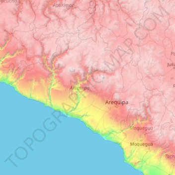
Name: Arequipa topographic map, elevation, terrain.
Location: Arequipa, Peru (-17.28501 -75.07199 -14.63274 -70.80408)
Average elevation: 2,599 m
Minimum elevation: 0 m
Maximum elevation: 6,195 m
Other topographic maps
Click on a map to view its topography, its elevation and its terrain.
La Rinconada
The town has gained notoriety for its extreme living conditions that include its high rates of altitude sickness, pollution, poverty, murder, and sex trafficking, and as a result has sometimes been referred to as in Spanish as "ciudad sin ley del Perú," which means "lawless city of Peru."
Average elevation: 4,923 m
Vinicunca
Vinicunca, or Winikunka, also called Montaña de Siete Colores (literally: Mountain of seven colors), Montaña de Colores (Mountain of colors) or Montaña Arcoíris (Rainbow Mountain), is a mountain in the Andes of Peru with an altitude of 5,200 metres (17,100 ft) above sea level. It is located on the road to…
Average elevation: 4,874 m
Lima
Relative humidity is always very high, particularly in the mornings. High humidity produces brief morning fog in the early summer and a usually persistent low cloud deck during the winter (generally develops in late May and persists until mid-November or even early December). The predominantly onshore flow…
Average elevation: 202 m