
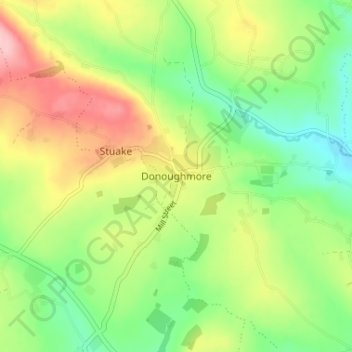
Donoughmore topographic map
Interactive map
Click on the map to display elevation.
About this map
Name: Donoughmore topographic map, elevation, terrain.
Average elevation: 183 m
Minimum elevation: 119 m
Maximum elevation: 272 m
Other topographic maps
Click on a map to view its topography, its elevation and its terrain.
Cork
Ireland > County Cork > Cork
Cork, County Cork, Munster, T12 T997, Ireland
Average elevation: 94 m
Castlepook
Castlepook, Ballinree Bridge, Streamhill, The Municipal District of Fermoy, County Cork, Munster, Ireland
Average elevation: 98 m
Knockeennagroagh
Knockeennagroagh, Gortroe, The Municipal District of Fermoy, County Cork, Munster, Ireland
Average elevation: 182 m
Knockeen
Knockeen, Coulagh ED ED, West Cork, County Cork, Munster, P75 PE80, Ireland
Average elevation: 145 m
Carriganimmy
Carriganimmy, Municipal District of Macroom, County Cork, Munster, P12 DW92, Ireland
Average elevation: 242 m
Ballineen
Ballineen, West Cork, County Cork, Munster, P47 R623, Ireland
Average elevation: 76 m
Arderrow
Ireland > County Cork > Cork
Arderrow, Rathcooney, Cork, County Cork, Munster, T23 P270, Ireland
Average elevation: 95 m
Corbally
Corbally, Kildinan, The Municipal District of Fermoy, County Cork, Munster, Ireland
Average elevation: 113 m
Great Island
Great Island, Municipal District of Cobh, County Cork, Munster, Ireland
Average elevation: 20 m
Maryborough
Ireland > County Cork > Cork
Maryborough, Douglas, Cork, County Cork, Munster, Ireland
Average elevation: 51 m
Drombeg
Drombeg, Kilfaughnabeg, West Cork, County Cork, Munster, Ireland
Average elevation: 77 m
Douglas
Ireland > County Cork > Cork
Douglas, Cork, County Cork, Munster, Ireland
Average elevation: 34 m
Lismire
Lismire, Barleyhill ED, The Municipal District of Kanturk-Mallow, County Cork, Munster, Ireland
Average elevation: 192 m
Bunlick
Bunlick, Skibbereen Rural, West Cork, County Cork, Munster, Ireland
Average elevation: 32 m
Lissardagh
Lissardagh, Warrenscourt, Municipal District of Macroom, County Cork, Munster, Ireland
Average elevation: 109 m
Ardgroom
Ardgroom, West Cork, County Cork, Munster, Ireland
Average elevation: 56 m
Millstreet
Millstreet, Municipal District of Macroom, County Cork, Munster, Ireland
Average elevation: 140 m
Meelin
Meelin, The Municipal District of Kanturk-Mallow, County Cork, Munster, Ireland
Average elevation: 246 m
Shanagarry
Shanagarry, The Municipal District of East Cork, County Cork, Munster, P25 HX82, Ireland
Average elevation: 14 m
Ardnahinch
Ardnahinch, Ballycottin ED, The Municipal District of East Cork, County Cork, Munster, Ireland
Average elevation: 5 m
Bandon
Bandon, The Municipal District of Bandon-Kinsale, County Cork, Munster, Ireland
Average elevation: 59 m
Curraglass
Curraglass, Templemary, The Municipal District of Kanturk-Mallow, County Cork, Munster, Ireland
Average elevation: 135 m
Kilgobbin
Kilgobbin, Ballinadee ED, The Municipal District of Bandon-Kinsale, County Cork, Munster, Ireland
Average elevation: 85 m
Ballincollig
Ireland > County Cork > Cork
Ballincollig, Cork, County Cork, Munster, P31 TW88, Ireland
Average elevation: 62 m
Inchigeelagh
Inchigeelagh, Municipal District of Macroom, County Cork, Munster, P12 W864, Ireland
Average elevation: 135 m
Knockawaddra
Knockawaddra, Ballingurteen ED, West Cork, County Cork, Munster, Ireland
Average elevation: 154 m
Killeagh
Killeagh, The Municipal District of East Cork, County Cork, Munster, P36 KN61, Ireland
Average elevation: 32 m
Water-rock
Water-rock, Carrigtohill ED, Municipal District of Cobh, County Cork, Munster, Ireland
Average elevation: 22 m
Coolmore Cross
Coolmore Cross, Carrigaline ED, Municipal District of Carrigaline, County Cork, Munster, P43 DA03, Ireland
Average elevation: 21 m
Gortroe
Gortroe, The Municipal District of Fermoy, County Cork, Munster, P61 TD96, Ireland
Average elevation: 120 m
Lyre
Lyre, Tincoora, The Municipal District of Kanturk-Mallow, County Cork, Munster, Ireland
Average elevation: 214 m
Dundareirke
Dundareirke, Kilnamartery, Municipal District of Macroom, County Cork, Munster, Ireland
Average elevation: 116 m
Castlemartyr
Castlemartyr, The Municipal District of East Cork, County Cork, Munster, Ireland
Average elevation: 14 m
Castletownroche
Castletownroche, The Municipal District of Fermoy, County Cork, Munster, P51 K064, Ireland
Average elevation: 67 m
Ballincollig Regional Park
Ireland > County Cork > Cork
Ballincollig Regional Park, West Village, Carrigrohane Beg ED, Cork, County Cork, Munster, Ireland
Average elevation: 55 m
Berrings
Berrings, Dripsey, Municipal District of Macroom, County Cork, Munster, Ireland
Average elevation: 113 m
Moneyreague
Moneyreague, Coolmountain ED, West Cork, County Cork, Munster, Ireland
Average elevation: 122 m
Ballymore
Ballymore, Cobh Rural ED, Municipal District of Cobh, County Cork, Munster, Ireland
Average elevation: 40 m
Macroom
Macroom, Municipal District of Macroom, County Cork, Munster, Ireland
Average elevation: 110 m
Waterfall
Waterfall, Inishkenny, Municipal District of Carrigaline, County Cork, Munster, T12 CYF2, Ireland
Average elevation: 96 m
Aghabullogue
Aghabullogue, Municipal District of Macroom, County Cork, Munster, P12 DY92, Ireland
Average elevation: 133 m
Liscahane Beg
Liscahane Beg, Kinsale Rural, The Municipal District of Bandon-Kinsale, County Cork, Munster, Ireland
Average elevation: 47 m
Mallow
Mallow, The Municipal District of Kanturk-Mallow, County Cork, Munster, Ireland
Average elevation: 77 m
Kilmurry
Kilmurry, Municipal District of Macroom, County Cork, Munster, P14 R940, Ireland
Average elevation: 122 m
Baltimore
Baltimore, West Cork, County Cork, Munster, P81 F623, Ireland
Average elevation: 23 m
Glounthaune
Glounthaune, Municipal District of Cobh, County Cork, Munster, T45 V201, Ireland
Average elevation: 52 m