
Great Island topographic map
Interactive map
Click on the map to display elevation.
Great Island
In the 19th century Topographical Dictionary of Ireland (published by Samuel Lewis in 1837), Great Island is described as "very fertile" with its "light productive soil" supporting agricultural uses with "two-thirds [of the island] under tillage, and the remainder in pasture or included in demesnes". Lewis describes the island's location, environment and climate as factors "induc[ing] many genteel families to settle here".
About this map
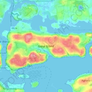
Name: Great Island topographic map, elevation, terrain.
Average elevation: 20 m
Minimum elevation: -12 m
Maximum elevation: 95 m
County Cork trails, hiking, mountain biking, running and outdoor activities
Other topographic maps
Click on a map to view its topography, its elevation and its terrain.