
La Guaira topographic map
Interactive map
Click on the map to display elevation.
About this map
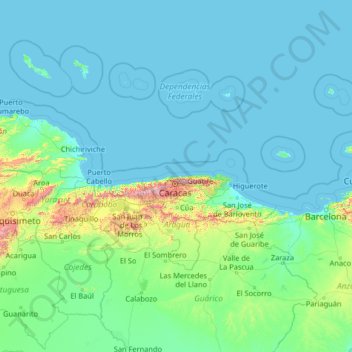
Name: La Guaira topographic map, elevation, terrain.
Location: La Guaira, Venezuela (8.01054 -69.49824 13.21054 -64.29824)
Average elevation: 116 m
Minimum elevation: -1 m
Maximum elevation: 2,590 m
Other topographic maps
Click on a map to view its topography, its elevation and its terrain.
Nueva Esparta State
Together, the three islands of the State bring together magnificent beaches, wonderful mangroves and other landscapes that make it a true island paradise. Margarita, the largest of them, has a maximum elevation on Copey Hill (900 meters above sea level) and includes the Macanao mountain core to the west. Coche…
Average elevation: 15 m
Anzoategui State
The vegetation of the Anzoátegui State is typical temperate. It is largely determined by altitude, climate and season of the year, where areas of snow-covered scrub, cujíes and small southern species alternate. It also has a tree called caderoms, this includes resistant or environmentally adapted varieties.
Average elevation: 156 m
Aragua State
Due to its diversity in relief and altitudes that it possesses in all its extension, there are different thermal floors in which the temperature tends to have different climatic characteristics and temperatures that decrease with the increase of the altitude, in the coastal strip dominates a semi-arid and warm…
Average elevation: 472 m
Luces de Puerto Ordaz (UD-246)
Venezuela > Bolivar State > Municipio Caroní > Puerto Ordaz
Average elevation: 108 m
Lara State
Lara's topography consist of high plains and low, broken hills, with a relatively hot and dry climate. Lara depression is located at altitudes between 1,600 and 2,600 ft (487 to 792 m). Among the landscapes of moderate height, the pressures of Carora, Barquisimeto and Yaracuy stand out, while the Sierra de…
Average elevation: 650 m