
Lara State topographic map
Interactive map
Click on the map to display elevation.
Lara State
Lara's topography consist of high plains and low, broken hills, with a relatively hot and dry climate. Lara depression is located at altitudes between 1,600 and 2,600 ft (487 to 792 m). Among the landscapes of moderate height, the pressures of Carora, Barquisimeto and Yaracuy stand out, while the Sierra de Aroa, the Nirgua Massif and the Andean buttress present more broken reliefs. The Barquisimeto high plateau is a privileged place for human settlement, commerce and communications, while the valley of the turbid river allows for intense agricultural use, in contrast to the aridity of the surrounding xerophytic vegetation. It is integrated by the last foothills of the Venezuelan Andes System, located in the south and southwest of the state respectively. The most pronounced altitude in the state is the Cendé Paramo at 3,585 m above sea level.
About this map
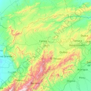
Name: Lara State topographic map, elevation, terrain.
Location: Lara State, Venezuela (9.38892 -70.88365 10.75388 -68.87509)
Average elevation: 650 m
Minimum elevation: -1 m
Maximum elevation: 3,875 m
Other topographic maps
Click on a map to view its topography, its elevation and its terrain.