
Make a donation
Gear up for your next adventure:
As an Amazon Associate, this site earns from qualifying purchases at no extra cost to you.
Anzoategui State topographic map
Click on the map to display elevation.
Make a donation
Gear up for your next adventure:
As an Amazon Associate, this site earns from qualifying purchases at no extra cost to you.
Anzoategui State
The vegetation of the Anzoátegui State is typical temperate. It is largely determined by altitude, climate and season of the year, where areas of snow-covered scrub, cujíes and small southern species alternate. It also has a tree called caderoms, this includes resistant or environmentally adapted varieties.
Make a donation
Gear up for your next adventure:
As an Amazon Associate, this site earns from qualifying purchases at no extra cost to you.
About this map
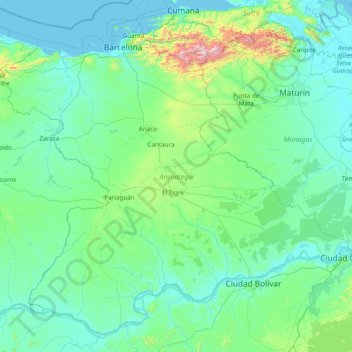
Name: Anzoategui State topographic map, elevation, terrain.
Location: Anzoategui State, Venezuela (7.66544 -65.75103 10.37411 -62.68819)
Average elevation: 156 m
Minimum elevation: -1 m
Maximum elevation: 2,431 m
Make a donation
Gear up for your next adventure:
As an Amazon Associate, this site earns from qualifying purchases at no extra cost to you.
Other topographic maps
Click on a map to view its topography, its elevation and its terrain.
Make a donation
Gear up for your next adventure:
As an Amazon Associate, this site earns from qualifying purchases at no extra cost to you.