Geolocate
👉 Easily get elevation data in JSON, GeoTIFF and KML formats using Elevation API
Thank you for supporting this site ❤️
Make a donation

Crossmaglen topographic map

Click on the map to display elevation.

👉 Easily get elevation data in JSON, GeoTIFF and KML formats using Elevation API
Thank you for supporting this site ❤️
Make a donation

About this map

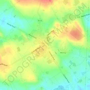
Name: Crossmaglen topographic map, elevation, terrain.

Location: Crossmaglen, Newry, Mourne and Down District Council, Northern Ireland, United Kingdom (54.07080 -6.61601 54.08226 -6.60061)

Average elevation: 123 m

Minimum elevation: 95 m

Maximum elevation: 154 m

Other topographic maps

Click on a map to view its topography, its elevation and its terrain.

Newry

United Kingdom > Northern Ireland > Newry

Average elevation: 119 m

Killough

United Kingdom > Northern Ireland

Average elevation: 7 m

Carryduff

United Kingdom > Northern Ireland > Carryduff

Average elevation: 121 m

Downpatrick

United Kingdom > Northern Ireland

Average elevation: 25 m

Newry

United Kingdom > Northern Ireland > County Down

Average elevation: 73 m

Longfield

United Kingdom > Northern Ireland

Average elevation: 121 m

Kilclief

United Kingdom > Northern Ireland

Average elevation: 6 m

Eglish

United Kingdom > Northern Ireland > County Tyrone

Average elevation: 195 m

Creeve

United Kingdom > Northern Ireland

Average elevation: 71 m

Dromore

United Kingdom > Northern Ireland > County Down

Average elevation: 106 m

Tullanafoile

United Kingdom > Northern Ireland

Average elevation: 145 m

Sturgan

United Kingdom > Northern Ireland

Average elevation: 146 m

Clonmore

United Kingdom > Northern Ireland

Average elevation: 19 m

Skerries

United Kingdom > Northern Ireland

Average elevation: 83 m

Slievebrack

United Kingdom > Northern Ireland

Average elevation: 126 m

Droghed

United Kingdom > Northern Ireland

Average elevation: 16 m

Tassagh

United Kingdom > Northern Ireland > Armagh

Average elevation: 109 m

Layd

United Kingdom > Northern Ireland

Average elevation: 77 m

Oughterard

United Kingdom > Northern Ireland

Average elevation: 115 m

Knappagh

United Kingdom > Northern Ireland

Average elevation: 83 m

Kildrum

United Kingdom > Northern Ireland

Average elevation: 100 m

Dooish

United Kingdom > Northern Ireland

Average elevation: 161 m

Mowhan

United Kingdom > Northern Ireland > County Armagh > Armagh

Average elevation: 115 m

Golf 20

United Kingdom > Northern Ireland

Average elevation: 94 m

Seafin

United Kingdom > Northern Ireland > County Armagh

Average elevation: 161 m

Armoy

United Kingdom > Northern Ireland > County Antrim > Armoy

Average elevation: 102 m

Dunluce

United Kingdom > Northern Ireland

Average elevation: 39 m

Meigh

United Kingdom > Northern Ireland > County Armagh > Meigh

Average elevation: 139 m

Deffrick

United Kingdom > Northern Ireland

Average elevation: 56 m

Meenagh

United Kingdom > Northern Ireland

Average elevation: 27 m

Drumnacross

United Kingdom > Northern Ireland

Average elevation: 111 m

Tullyard

United Kingdom > Northern Ireland

Average elevation: 73 m

Listooder

United Kingdom > Northern Ireland

Average elevation: 57 m

Craiganboy

United Kingdom > Northern Ireland

Average elevation: 72 m

Magherabeg

United Kingdom > Northern Ireland

Average elevation: 99 m

Shanmullagh

United Kingdom > Northern Ireland

Average elevation: 116 m

Cloghram

United Kingdom > Northern Ireland

Average elevation: 24 m

Drumbo

United Kingdom > Northern Ireland > County Down > Drumbo

Average elevation: 94 m

Mullaghglass

United Kingdom > Northern Ireland

Average elevation: 47 m

Lisbunny

United Kingdom > Northern Ireland

Average elevation: 193 m

Moymore

United Kingdom > Northern Ireland

Average elevation: 174 m

Ballykillare

United Kingdom > Northern Ireland

Average elevation: 46 m

Ballycairn

United Kingdom > Northern Ireland

Average elevation: 21 m

Turmore

United Kingdom > Northern Ireland

Average elevation: 56 m

Cullion

United Kingdom > Northern Ireland

Average elevation: 94 m

Drumgoose

United Kingdom > Northern Ireland

Average elevation: 25 m

Gear up for your next adventure:

🧂Electrolyte Tablets - Stay hydrated during strenuous mountain climbs
🧯Camp Safety Kits - All‑in‑one safety gear
🧯Portable Extinguishers - Safety tools for campfires
🎒Backpack Rain Covers - Extra protection for non-waterproof rucksacks
🥾Men's Waterproof Boots - Sturdy footwear for wet and boggy Irish terrain

As an Amazon Associate, this site earns from qualifying purchases at no extra cost to you.