Geolocate
👉 Easily get elevation data in JSON, GeoTIFF and KML formats using Elevation API
Thank you for supporting this site ❤️
Make a donation

Dromore topographic map

Click on the map to display elevation.

👉 Easily get elevation data in JSON, GeoTIFF and KML formats using Elevation API
Thank you for supporting this site ❤️
Make a donation

Gear up for your next adventure:

As an Amazon Associate, this site earns from qualifying purchases at no extra cost to you.

About this map

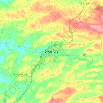
Name: Dromore topographic map, elevation, terrain.

Location: Dromore, County Down, Ulster, Northern Ireland, BT25 1BD, United Kingdom (54.37527 -6.18951 54.45527 -6.10951)

Average elevation: 106 m

Minimum elevation: 56 m

Maximum elevation: 172 m

Other topographic maps

Click on a map to view its topography, its elevation and its terrain.

Newry

United Kingdom > Northern Ireland > County Down

Average elevation: 73 m

Gear up for your next adventure:

🪢Paracord & Ropes - Strong ropes for camping and gear
🩰Hiking Binoculars - See long distances on trails
🥾Women's Waterproof Boots - Gore-Tex protection for trail and mountain walking
🗺️Irish Road Atlases - Comprehensive physical maps for road trips and navigation
🔪Multi‑Tools & Knives - Versatile tools for outdoor tasks

As an Amazon Associate, this site earns from qualifying purchases at no extra cost to you.