
Make a donation
Gear up for your next adventure:
As an Amazon Associate, this site earns from qualifying purchases at no extra cost to you.
Kane County topographic map
Click on the map to display elevation.
Make a donation
Gear up for your next adventure:
As an Amazon Associate, this site earns from qualifying purchases at no extra cost to you.
About this map
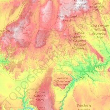
Name: Kane County topographic map, elevation, terrain.
Location: Kane County, Utah, United States (37.00031 -112.90511 37.54489 -110.63927)
Average elevation: 1,912 m
Minimum elevation: 952 m
Maximum elevation: 3,439 m
Make a donation
Gear up for your next adventure:
As an Amazon Associate, this site earns from qualifying purchases at no extra cost to you.
Other topographic maps
Click on a map to view its topography, its elevation and its terrain.
Y Mountain
United States > Utah > Utah County > Provo
Y Mountain is a mountain located directly east of Brigham Young University (BYU) in Provo, Utah, United States. The Slide Canyon, or Y Mountain Trail, leads to a large block Y located 1.06 miles (1.71 km) from a parking area at the mountain's base with an elevation gain of 1,074 feet (327 m). This hillside…
Average elevation: 2,154 m
Mammoth Cave
United States > Utah > Garfield County
Mammoth Cave is a lava tube located on the Markagunt Plateau in the Dixie National Forest of Southern Utah, and is one of the largest lava tubes in Utah. The cave has over 2,200 feet (670 m) of passage and is about a quarter mile (400 m) long. It was formed by cooling lava and water less than 2,000 years ago.…
Average elevation: 2,422 m
Provo Peak
United States > Utah > Utah County > Provo
Provo Peak is a mountain peak located in the Wasatch Range and the Uinta National Forest that is located within the city limits of Provo, Utah, United States. The peak has an elevation of 11,068 feet (3,374 m), but a prominence of only 3,442 feet (1,049 m). Although located along the Wasatch Front, it is…
Average elevation: 2,907 m
Make a donation
Gear up for your next adventure:
As an Amazon Associate, this site earns from qualifying purchases at no extra cost to you.
Mount Lebannon Acres
United States > Utah > Davis County > Centerville > Rosedale
Average elevation: 1,464 m
South Valence Drainage
United States > Utah > Salt Lake County > West Jordan
Average elevation: 1,388 m
Make a donation
Gear up for your next adventure:
As an Amazon Associate, this site earns from qualifying purchases at no extra cost to you.