
The Great White Throne topographic map
Interactive map
Click on the map to display elevation.
About this map
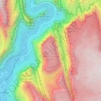
Name: The Great White Throne topographic map, elevation, terrain.
Average elevation: 1,732 m
Minimum elevation: 1,300 m
Maximum elevation: 2,115 m
Other topographic maps
Click on a map to view its topography, its elevation and its terrain.
Saint George
United States > Utah > Washington County
Saint George, Washington County, Utah, United States
Average elevation: 929 m