
Make a donation
Gear up for your next adventure:
As an Amazon Associate, this site earns from qualifying purchases at no extra cost to you.
Schwenda topographic map
Click on the map to display elevation.
Make a donation
Gear up for your next adventure:
As an Amazon Associate, this site earns from qualifying purchases at no extra cost to you.
Schwenda
Der achteckige Rundbau, der auf acht Säulen ruht, hat eine Außenhöhe von 34 m und einen Innendurchmesser von 15 m. Das Kuppelgewölbe zeigt in der Mitte das Gottesauge, darum gruppieren sich die Bilder der vier Evangelisten und darunter die vier Erzengel, dazwischen sind die Jahreszeichen und die alten Monatszeichen ausgemalt. Die Ausstattung aus der Erbauungszeit ist erhalten.
Make a donation
Gear up for your next adventure:
As an Amazon Associate, this site earns from qualifying purchases at no extra cost to you.
About this map
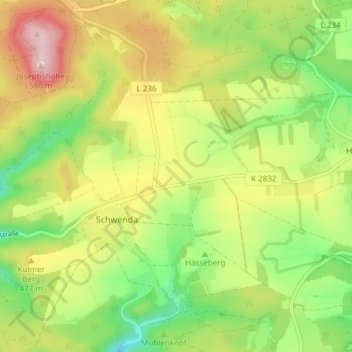
Name: Schwenda topographic map, elevation, terrain.
Average elevation: 449 m
Minimum elevation: 340 m
Maximum elevation: 583 m
Make a donation
Gear up for your next adventure:
As an Amazon Associate, this site earns from qualifying purchases at no extra cost to you.
Other topographic maps
Click on a map to view its topography, its elevation and its terrain.
Make a donation
Gear up for your next adventure:
As an Amazon Associate, this site earns from qualifying purchases at no extra cost to you.
Make a donation
Gear up for your next adventure:
As an Amazon Associate, this site earns from qualifying purchases at no extra cost to you.
Rohnetal
Deutschland > Sachsen-Anhalt > Mansfeld-Südharz > Allstedt > Wolferstedt
Average elevation: 172 m
Make a donation
Gear up for your next adventure:
As an Amazon Associate, this site earns from qualifying purchases at no extra cost to you.
Großer Auerberg
Deutschland > Sachsen-Anhalt > Mansfeld-Südharz
Der Große Auerberg im Harz ist ein 580,4 m ü. NHN hoher Berg bei Stolberg im Gemeindegebiet von Südharz im Landkreis Mansfeld-Südharz in Sachsen-Anhalt. Es handelt sich um einen Doppelgipfel von 580,4 m (Großer Auerberg) und 580,3 m (Josephshöhe) Höhe, die etwa 470 m auseinander liegen.
Average elevation: 479 m
Popperode
Deutschland > Sachsen-Anhalt > Mansfeld-Südharz > Sangerhausen > Popperode
Average elevation: 328 m
Make a donation
Gear up for your next adventure:
As an Amazon Associate, this site earns from qualifying purchases at no extra cost to you.
Hedersleben (b. Eisleben)
Deutschland > Sachsen-Anhalt > Mansfeld-Südharz > Lutherstadt Eisleben > Hedersleben (b. Eisleben)
Average elevation: 201 m
Wolferode
Deutschland > Sachsen-Anhalt > Mansfeld-Südharz > Lutherstadt Eisleben > Wolferode
Average elevation: 230 m
Sittendorf
Deutschland > Sachsen-Anhalt > Mansfeld-Südharz > Kelbra (Kyffhäuser)
Average elevation: 203 m