
Make a donation
Gear up for your next adventure:
As an Amazon Associate, this site earns from qualifying purchases at no extra cost to you.
Siebigerode topographic map
Click on the map to display elevation.
Make a donation
Gear up for your next adventure:
As an Amazon Associate, this site earns from qualifying purchases at no extra cost to you.
About this map
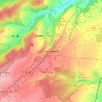
Name: Siebigerode topographic map, elevation, terrain.
Average elevation: 284 m
Minimum elevation: 196 m
Maximum elevation: 340 m
Make a donation
Gear up for your next adventure:
As an Amazon Associate, this site earns from qualifying purchases at no extra cost to you.
Other topographic maps
Click on a map to view its topography, its elevation and its terrain.
Make a donation
Gear up for your next adventure:
As an Amazon Associate, this site earns from qualifying purchases at no extra cost to you.
Siebigerode
Deutschland > Sachsen-Anhalt > Mansfeld-Südharz > Mansfeld
Siebigerode liegt im östlichen Harzvorland (Mansfelder Land) auf einer Höhe von ca. 309 m NHN.. Durch den Ort führt die Bundesstraße 86 (Abschnitt Mansfeld - Sangerhausen). Der Ort liegt am Kreuzbach, der südwestlich der Ortslage beginnt und nach Nordosten in Richtung des Hagenbaches (Zufluss zum…
Average elevation: 286 m
Make a donation
Gear up for your next adventure:
As an Amazon Associate, this site earns from qualifying purchases at no extra cost to you.