
Make a donation
Gear up for your next adventure:
As an Amazon Associate, this site earns from qualifying purchases at no extra cost to you.
Sittendorf topographic map
Click on the map to display elevation.
Make a donation
Gear up for your next adventure:
As an Amazon Associate, this site earns from qualifying purchases at no extra cost to you.
About this map
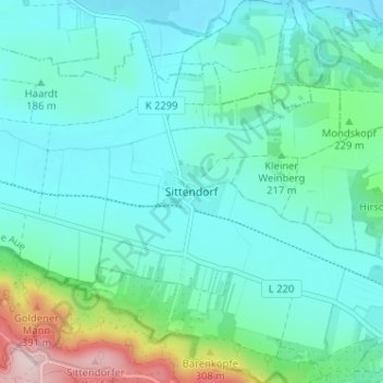
Name: Sittendorf topographic map, elevation, terrain.
Average elevation: 203 m
Minimum elevation: 141 m
Maximum elevation: 467 m
Make a donation
Gear up for your next adventure:
As an Amazon Associate, this site earns from qualifying purchases at no extra cost to you.
Other topographic maps
Click on a map to view its topography, its elevation and its terrain.
Tilleda (Kyffhäuser)
Deutschland > Sachsen-Anhalt > Mansfeld-Südharz > Kelbra (Kyffhäuser)
Tilleda liegt in der Goldenen Aue, direkt am Nordrand des Kyffhäusergebirges. Durch den Ort fließt der aus dem Kyffhäusergebirge kommende Wolweda Bach, Hauptzufluss zur Kleinen Helme (Gewässerzahl 5647.6). Nördlich des Ortes befinden sich inmitten der Goldenen Aue die kleineren Höhen der Sittendorfer…
Average elevation: 211 m