
Make a donation
Gear up for your next adventure:
As an Amazon Associate, this site earns from qualifying purchases at no extra cost to you.
Free State topographic map
Click on the map to display elevation.
Make a donation
Gear up for your next adventure:
As an Amazon Associate, this site earns from qualifying purchases at no extra cost to you.
Free State
The Free State is situated on a succession of flat grassy plains sprinkled with pastureland, resting on a general elevation of 3,800 feet only broken by the occasional hill or kopje. The rich soil and pleasant climate allow for a thriving agricultural industry.
Make a donation
Gear up for your next adventure:
As an Amazon Associate, this site earns from qualifying purchases at no extra cost to you.
About this map
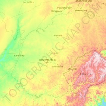
Name: Free State topographic map, elevation, terrain.
Location: Free State, South Africa (-30.69408 24.34662 -26.66874 29.78513)
Average elevation: 1,499 m
Minimum elevation: 980 m
Maximum elevation: 3,379 m
Make a donation
Gear up for your next adventure:
As an Amazon Associate, this site earns from qualifying purchases at no extra cost to you.
Other topographic maps
Click on a map to view its topography, its elevation and its terrain.
Cape Town
South Africa > Western Cape > City of Cape Town
The Cape Peninsula is 52 km long from Mouille Point in the north to Cape Point in the south, with an area of about 470 km2, and it displays more topographical variety than other similar sized areas in southern Africa, and consequently spectacular scenery. There are diverse low-nutrient soils, large rocky…
Average elevation: 53 m
Johannesburg
South Africa > Gauteng > City of Johannesburg Metropolitan Municipality
Johannesburg is located in the eastern plateau area of South Africa known as the Highveld, at an elevation of 1,753 metres (5,751 ft). The former Central Business District is located on the southern side of the prominent ridge called the Witwatersrand (English: White Water's Ridge) and the terrain falls to the…
Average elevation: 1,615 m
Empangeni
South Africa > KwaZulu-Natal > King Cetswayo District Municipality > uMhlathuze Local Municipality
Average elevation: 89 m
Make a donation
Gear up for your next adventure:
As an Amazon Associate, this site earns from qualifying purchases at no extra cost to you.
Thabazimbi
South Africa > Limpopo > Waterberg District Municipality > Thabazimbi Local Municipality
Average elevation: 1,077 m
Johannesburg
South Africa > Gauteng > City of Johannesburg Metropolitan Municipality
Johannesburg is located in the eastern plateau area of South Africa known as the Highveld, at an elevation of 1,753 metres (5,751 ft). The former Central Business District is located on the southern side of the prominent ridge called the Witwatersrand (English: White Water's Ridge) and the terrain falls to the…
Average elevation: 1,615 m
Make a donation
Gear up for your next adventure:
As an Amazon Associate, this site earns from qualifying purchases at no extra cost to you.
Johannesburg
South Africa > Gauteng > City of Johannesburg Metropolitan Municipality
Johannesburg is located in the eastern plateau area of South Africa known as the Highveld, at an elevation of 1,753 metres (5,751 ft). The former Central Business District is located on the southern side of the prominent ridge called the Witwatersrand (English: White Water's Ridge) and the terrain falls to the…
Average elevation: 1,615 m
Matatiele
South Africa > Eastern Cape > Alfred Nzo District Municipality > Matatiele Local Municipality
Average elevation: 1,603 m
Jeffreys Bay
South Africa > Eastern Cape > Sarah Baartman District Municipality > Kouga Local Municipality
Average elevation: 30 m
Make a donation
Gear up for your next adventure:
As an Amazon Associate, this site earns from qualifying purchases at no extra cost to you.
Wasbank
South Africa > KwaZulu-Natal > Uthukela District Municipality > Indaka Local Municipality
Average elevation: 1,071 m
Vrede
South Africa > Free State > Thabo Mofutsanyana District Municipality > Phumelela Local Municipality
Average elevation: 1,678 m
Make a donation
Gear up for your next adventure:
As an Amazon Associate, this site earns from qualifying purchases at no extra cost to you.
Ramsgate
South Africa > KwaZulu-Natal > Ugu District Municipality > Hibiscus Coast Local Municipality
Average elevation: 29 m
Moorreesburg
South Africa > Western Cape > West Coast District Municipality > Swartland Local Municipality
Average elevation: 172 m
KuGompo City
South Africa > Eastern Cape > Buffalo City Metropolitan Municipality
Average elevation: 72 m
Hartbeespoort Dam
South Africa > North West > Bojanala Platinum District Municipality > Madibeng Local Municipality > Kosmos
Average elevation: 1,254 m
Make a donation
Gear up for your next adventure:
As an Amazon Associate, this site earns from qualifying purchases at no extra cost to you.
Bothaville
South Africa > Free State > Lejweleputswa District Municipality > Nala Local Municipality
Average elevation: 1,287 m
Soweto
South Africa > Gauteng > City of Johannesburg Metropolitan Municipality
Average elevation: 1,638 m
Pretoria
South Africa > Gauteng > City of Tshwane Metropolitan Municipality
Pretoria is situated approximately 55 km (34 mi) north-northeast of Johannesburg in the northeast of South Africa, in a transitional belt between the plateau of the Highveld to the south and the lower-lying Bushveld to the north. It lies at an altitude of about 1,339 m (4,393 ft) above sea level, in a warm,…
Average elevation: 1,363 m
Make a donation
Gear up for your next adventure:
As an Amazon Associate, this site earns from qualifying purchases at no extra cost to you.
Tzaneen
South Africa > Limpopo > Mopani District Municipality > Greater Tzaneen Local Municipality
Average elevation: 737 m
Suikerbosrand Nature Reserve
South Africa > Gauteng > Sedibeng District Municipality > Lesedi Local Municipality
Suikerbosrand Nature Reserve is a protected area which encompasses most of the Suikerbosrand Range, South Africa. It is one of Gauteng's most frequented ecotourism locations, located approximately 50 kilometres south-east of Johannesburg, just west of the town of Heidelberg in the upper catchment of the Klip…
Average elevation: 1,617 m
Pietermaritzburg
South Africa > KwaZulu-Natal > uMgungundlovu District Municipality
Average elevation: 853 m
Make a donation
Gear up for your next adventure:
As an Amazon Associate, this site earns from qualifying purchases at no extra cost to you.
Stellenbosch
South Africa > Western Cape > Cape Winelands District Municipality > Stellenbosch Local Municipality
Stellenbosch is 53 km (33 mi) east of Cape Town via National Route N1. Stellenbosch is in a hilly region of the Cape Winelands, and is sheltered in a valley at an average elevation of 136 m (446 ft), flanked on the west by Papegaaiberg (Afrikaans: Parrot Mountain), which is actually a hill. To the south is…
Average elevation: 287 m
Durban North
South Africa > KwaZulu-Natal > eThekwini Metropolitan Municipality
Average elevation: 41 m
Midrand
South Africa > Gauteng > City of Johannesburg Metropolitan Municipality
Average elevation: 1,542 m
Make a donation
Gear up for your next adventure:
As an Amazon Associate, this site earns from qualifying purchases at no extra cost to you.
Mashamba
South Africa > Limpopo > Vhembe District Municipality > Makhado Local Municipality
Average elevation: 587 m
Kamhlushwa
South Africa > Mpumalanga > Ehlanzeni District Municipality > Nkomazi
Average elevation: 254 m
Vygeboom Dam
South Africa > Mpumalanga > Gert Sibande > Albert Luthuli Local Municipality
Average elevation: 1,056 m
Make a donation
Gear up for your next adventure:
As an Amazon Associate, this site earns from qualifying purchases at no extra cost to you.
Bloemfontein
South Africa > Free State > Mangaung Metropolitan Municipality
Situated at an elevation of 1,395 m (4,577 ft) above sea level, the city is home to approximately 520,000 residents and forms part of the Mangaung Metropolitan Municipality which has a population of 747,431. It was one of the host cities for the 2010 FIFA World Cup.
Average elevation: 1,374 m
Worcester
South Africa > Western Cape > Cape Winelands District Municipality > Breede Valley Local Municipality
Worcester is located at an elevation of 220 metres (720 ft) and can be reached by road either travelling on the N1 highway through the Huguenot Tunnel or by driving through spectacular mountain passes. From Cape Town Du Toitskloof, from Wellington Bainskloof, from Malmesbury, Western Cape Nieuwekloof, from…
Average elevation: 252 m
Kempton Park
South Africa > Gauteng > City of Ekurhuleni Metropolitan Municipality
Average elevation: 1,654 m
Table Mountain
South Africa > Western Cape > City of Cape Town > Cape Town
Table Mountain is at the northern end of a sandstone mountain range that forms the spine of the Cape Peninsula that terminates approximately 50 kilometres (30 mi) to the south at the Cape of Good Hope and Cape Point. Immediately to the south of Table Mountain is a rugged "plateau" at a somewhat lower elevation…
Average elevation: 583 m
Make a donation
Gear up for your next adventure:
As an Amazon Associate, this site earns from qualifying purchases at no extra cost to you.
Vaal Dam
South Africa > Free State > Fezile Dabi District Municipality > Metsimaholo Local Municipality > Deneysville
Average elevation: 1,481 m
Klipkoppie Dam
South Africa > Mpumalanga > Ehlanzeni District Municipality > Mbombela
Average elevation: 973 m
Magaliesberg Biosphere Reserve
The reserve includes a variety of landscapes including slopes, cliffs, crests, kloofs, rivers, wetlands and valleys. Although the area covers a diverse geological area, it consists mainly of the Magaliesberg mountain complex comprising two geological formations: the Transvaal System and the Bushveld Igneous…
Average elevation: 1,366 m
Make a donation
Gear up for your next adventure:
As an Amazon Associate, this site earns from qualifying purchases at no extra cost to you.
Tesselaarsdal
South Africa > Western Cape > Theewaterskloof Local Municipality
Average elevation: 273 m
Make a donation
Gear up for your next adventure:
As an Amazon Associate, this site earns from qualifying purchases at no extra cost to you.
Gqeberha
South Africa > Eastern Cape > Nelson Mandela Bay Metropolitan Municipality
Average elevation: 37 m
Lephalale
South Africa > Limpopo > Waterberg District Municipality > Lephalale Local Municipality
Average elevation: 831 m
Make a donation
Gear up for your next adventure:
As an Amazon Associate, this site earns from qualifying purchases at no extra cost to you.
Prince Albert
South Africa > Western Cape > Central Karoo District Municipality > Prince Albert Local Municipality
Average elevation: 656 m
Postmasburg
South Africa > Northern Cape > ZF Mgcawu District Municipality > Tsantsabane Local Municipality
Average elevation: 1,327 m
Pongola
South Africa > KwaZulu-Natal > Zululand District Municipality > uPhongolo Local Municipality
Average elevation: 291 m
Make a donation
Gear up for your next adventure:
As an Amazon Associate, this site earns from qualifying purchases at no extra cost to you.
St. Francis Bay
South Africa > Eastern Cape > Sarah Baartman District Municipality > Kouga Local Municipality
Average elevation: 25 m
Vanderbijlpark
South Africa > Gauteng > Sedibeng District Municipality > Emfuleni Local Municipality
Vanderbijlpark is situated on the highveld of South Africa, at an altitude of 1,500 meters on the banks of the Vaal River. Summers in the city are warm to hot with an average high between 31 and 35°C, and an average low between 15 and 22°C. Winters in the city are cool to warm with an average high of between…
Average elevation: 1,474 m
Randburg
South Africa > Gauteng > City of Johannesburg Metropolitan Municipality
Average elevation: 1,567 m
Umlazi
South Africa > KwaZulu-Natal > eThekwini Metropolitan Municipality
Umlazi is situated on a series of undulating hills at an average elevation of 101 metres above sea level between the uMlaza River to the north and the uMbokodweni River to the south. Another river running through Umlazi is the Siphingo River which also runs towards the south of the township.
Average elevation: 100 m
Make a donation
Gear up for your next adventure:
As an Amazon Associate, this site earns from qualifying purchases at no extra cost to you.
Parys
South Africa > Free State > Fezile Dabi District Municipality > Ngwathe Local Municipality
Average elevation: 1,408 m
Springs
South Africa > Gauteng > City of Ekurhuleni Metropolitan Municipality
Average elevation: 1,606 m
Make a donation
Gear up for your next adventure:
As an Amazon Associate, this site earns from qualifying purchases at no extra cost to you.
Piet Retief
South Africa > Mpumalanga > Gert Sibande > Mkhondo Local Municipality
Average elevation: 1,276 m
Phuthaditjhaba
South Africa > Free State > Thabo Mofutsanyana District Municipality > Maluti-a-Phofung Local Municipality
Average elevation: 1,736 m
Benoni
South Africa > Gauteng > City of Ekurhuleni Metropolitan Municipality
Average elevation: 1,645 m
Make a donation
Gear up for your next adventure:
As an Amazon Associate, this site earns from qualifying purchases at no extra cost to you.
Nottingham Road
South Africa > KwaZulu-Natal > uMgungundlovu District Municipality > uMgeni Local Municipality
Average elevation: 1,478 m
Thononda
South Africa > Limpopo > Vhembe District Municipality > Mutale Local Municipality
Average elevation: 1,295 m
Lydenburg
South Africa > Mpumalanga > Ehlanzeni District Municipality > Thaba Chweu Local Municipality
Average elevation: 1,424 m
Make a donation
Gear up for your next adventure:
As an Amazon Associate, this site earns from qualifying purchases at no extra cost to you.
Nquthu
South Africa > KwaZulu-Natal > Umzinyathi District Municipality > Nquthu Local Municipality
Average elevation: 1,175 m
Qumbu
South Africa > Eastern Cape > O.R. Tambo District Municipality > Mhlontlo Local Municipality
Average elevation: 987 m
Ulundi
South Africa > KwaZulu-Natal > Zululand District Municipality > Ulundi Local Municipality
Average elevation: 586 m
Rooikoppies Dam
South Africa > North West > Bojanala Platinum District Municipality > Madibeng Local Municipality
Average elevation: 1,047 m
Make a donation
Gear up for your next adventure:
As an Amazon Associate, this site earns from qualifying purchases at no extra cost to you.
Hendrina
South Africa > Mpumalanga > Nkangala > Steve Tshwete Local Municipality
Average elevation: 1,672 m
Tugela
South Africa > KwaZulu-Natal > iLembe District Municipality > Mandeni Local Municipality
Average elevation: 61 m
Molelema
South Africa > North West > Dr Ruth Segomotsi Mompati District Municipality > Greater Taung Local Municipality
Average elevation: 1,296 m
Underberg
South Africa > KwaZulu-Natal > Sisonke District Municipality > Kwa Sani Local Municipality
Average elevation: 1,552 m
Make a donation
Gear up for your next adventure:
As an Amazon Associate, this site earns from qualifying purchases at no extra cost to you.
Edenville
South Africa > Free State > Fezile Dabi District Municipality > Ngwathe Local Municipality
Average elevation: 1,514 m
Kruger Park
South Africa > Gauteng > City of Johannesburg Metropolitan Municipality > Roodepoort
Average elevation: 1,708 m
Manyii
South Africa > Limpopo > Vhembe District Municipality > Makhado Local Municipality
Average elevation: 912 m
Make a donation
Gear up for your next adventure:
As an Amazon Associate, this site earns from qualifying purchases at no extra cost to you.
Evaton
South Africa > Gauteng > Sedibeng District Municipality > Emfuleni Local Municipality
Average elevation: 1,522 m
Schweizer-Reneke
South Africa > North West > Dr Ruth Segomotsi Mompati District Municipality > Mamusa Local Municipality
Average elevation: 1,318 m
Stilfontein
South Africa > North West > Dr Kenneth Kaunda District Municipality > Matlosana Local Municipality
Average elevation: 1,346 m
Make a donation
Gear up for your next adventure:
As an Amazon Associate, this site earns from qualifying purchases at no extra cost to you.
Rustenburg
South Africa > North West > Bojanala Platinum District Municipality
Rustenburg has a humid subtropical climate (Köppen Cwa), with a relatively high degree of diurnal temperature variation due to the high elevation. It has very warm summers (from December to February) and mild winters (from June to August). Due to the altitude, summers are not quite as hot as one might expect.…
Average elevation: 1,217 m
Franschhoek
South Africa > Western Cape > Cape Winelands District Municipality > Stellenbosch Local Municipality
Average elevation: 502 m
Kanyamazane
South Africa > Mpumalanga > Ehlanzeni District Municipality > Mbombela
Average elevation: 637 m
Make a donation
Gear up for your next adventure:
As an Amazon Associate, this site earns from qualifying purchases at no extra cost to you.
Klerksdorp
South Africa > North West > Dr Kenneth Kaunda District Municipality
Average elevation: 1,346 m
Vryburg
South Africa > North West > Dr Ruth Segomotsi Mompati District Municipality > Naledi Local Municipality
Average elevation: 1,205 m
Sasolburg
South Africa > Free State > Fezile Dabi District Municipality > Metsimaholo Local Municipality
Sasolburg is at a high altitude with a fairly dry climate and large seasonal temperature variation. It is situated on the banks of the Vaal River, which separates the Free State from the former Transvaal Province, and is not far from the Vaal Dam where excellent windsurfing spots can be found.
Average elevation: 1,469 m
Stanger / KwaDukuza
South Africa > KwaZulu-Natal > iLembe District Municipality > KwaDukuza Local Municipality
Average elevation: 96 m
Make a donation
Gear up for your next adventure:
As an Amazon Associate, this site earns from qualifying purchases at no extra cost to you.
Springbok
South Africa > Northern Cape > Namakwa District Municipality > Nama Khoi Local Municipality
The town lies at an elevation of 1,007 metres (3,304 feet) in a narrow valley between the high granite domes of the Klein Koperberge (Small Copper Mountains). This name gives away the reason for the early settlement which gradually turned into a major commercial and administrative centre for copper mining…
Average elevation: 927 m
De Aar
South Africa > Northern Cape > Pixley ka Seme District Municipality > Emthanjeni Local Municipality
Average elevation: 1,257 m
Groblersdal
South Africa > Limpopo > Sekhukhune District Municipality > Elias Motsoaledi Local Municipality
Average elevation: 939 m
Ixopo
South Africa > KwaZulu-Natal > Sisonke District Municipality > Ubuhlebezwe Local Municipality
Average elevation: 1,009 m
Make a donation
Gear up for your next adventure:
As an Amazon Associate, this site earns from qualifying purchases at no extra cost to you.