
Make a donation
Gear up for your next adventure:
As an Amazon Associate, this site earns from qualifying purchases at no extra cost to you.
Mthatha topographic map
Click on the map to display elevation.
Make a donation
Gear up for your next adventure:
As an Amazon Associate, this site earns from qualifying purchases at no extra cost to you.
About this map
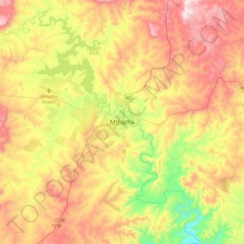
Name: Mthatha topographic map, elevation, terrain.
Average elevation: 783 m
Minimum elevation: 393 m
Maximum elevation: 1,206 m
Make a donation
Gear up for your next adventure:
As an Amazon Associate, this site earns from qualifying purchases at no extra cost to you.
Other topographic maps
Click on a map to view its topography, its elevation and its terrain.
Ingquza Hill Local Municipality
South Africa > Eastern Cape > O.R. Tambo District Municipality
Average elevation: 526 m
Mkambati Nature Reserve
South Africa > Eastern Cape > O.R. Tambo District Municipality > Ingquza Hill Local Municipality
Average elevation: 130 m
Tina River
South Africa > Eastern Cape > O.R. Tambo District Municipality > Mhlontlo Local Municipality
Average elevation: 777 m
Pondoland Marine Protected Area
South Africa > Eastern Cape > O.R. Tambo District Municipality
The MPA includes the water column, the seabed, and the air-space to an altitude of 1000 m above sea level in the area bounded by.
Average elevation: 122 m
Make a donation
Gear up for your next adventure:
As an Amazon Associate, this site earns from qualifying purchases at no extra cost to you.
Port St Johns Local Municipality
South Africa > Eastern Cape > O.R. Tambo District Municipality
Average elevation: 269 m
Nyandeni Local Municipality
South Africa > Eastern Cape > O.R. Tambo District Municipality
Average elevation: 569 m
King Sabata Dalindyebo Local Municipality
South Africa > Eastern Cape > O.R. Tambo District Municipality
Average elevation: 742 m
Tsitsa River
South Africa > Eastern Cape > O.R. Tambo District Municipality > Nyandeni Local Municipality
Average elevation: 703 m
Make a donation
Gear up for your next adventure:
As an Amazon Associate, this site earns from qualifying purchases at no extra cost to you.
Nyandeni Local Municipality
South Africa > Eastern Cape > O.R. Tambo District Municipality
Average elevation: 569 m
Tina River
South Africa > Eastern Cape > O.R. Tambo District Municipality > Mhlontlo Local Municipality
Average elevation: 557 m
Ingquza Hill Local Municipality
South Africa > Eastern Cape > O.R. Tambo District Municipality
Average elevation: 526 m