
Make a donation
Gear up for your next adventure:
As an Amazon Associate, this site earns from qualifying purchases at no extra cost to you.
Makhanda topographic map
Click on the map to display elevation.
Make a donation
Gear up for your next adventure:
As an Amazon Associate, this site earns from qualifying purchases at no extra cost to you.
About this map
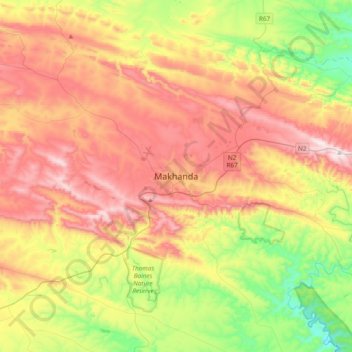
Name: Makhanda topographic map, elevation, terrain.
Average elevation: 458 m
Minimum elevation: 101 m
Maximum elevation: 848 m
Make a donation
Gear up for your next adventure:
As an Amazon Associate, this site earns from qualifying purchases at no extra cost to you.
Other topographic maps
Click on a map to view its topography, its elevation and its terrain.
Krom River
South Africa > Eastern Cape > Sarah Baartman District Municipality > Kouga Local Municipality > Kromrivier
Average elevation: 43 m
Gamtoos River
South Africa > Eastern Cape > Sarah Baartman District Municipality
Average elevation: 261 m
Sundays River Valley Local Municipality
South Africa > Eastern Cape > Sarah Baartman District Municipality
Average elevation: 317 m
Make a donation
Gear up for your next adventure:
As an Amazon Associate, this site earns from qualifying purchases at no extra cost to you.
Garden Route National Park
South Africa > Eastern Cape > Sarah Baartman District Municipality
Average elevation: 386 m
Kouga Dam
South Africa > Eastern Cape > Sarah Baartman District Municipality > Kouga Local Municipality
Average elevation: 275 m
Churchill Dam
South Africa > Eastern Cape > Sarah Baartman District Municipality > Kou-Kamma Local Municipality
Average elevation: 230 m
Ndlambe Local Municipality
South Africa > Eastern Cape > Sarah Baartman District Municipality
Average elevation: 161 m
Make a donation
Gear up for your next adventure:
As an Amazon Associate, this site earns from qualifying purchases at no extra cost to you.
Buffalo Kloof Protected Environment
South Africa > Eastern Cape > Sarah Baartman District Municipality > Makana Local Municipality
Average elevation: 284 m
Grey Dam
South Africa > Eastern Cape > Sarah Baartman District Municipality > Makhanda
Average elevation: 600 m
Glen Melville Dam
South Africa > Eastern Cape > Sarah Baartman District Municipality > Makana Local Municipality
Average elevation: 286 m
Makana Ward 14
South Africa > Eastern Cape > Sarah Baartman District Municipality > Makana Local Municipality
Average elevation: 430 m
Make a donation
Gear up for your next adventure:
As an Amazon Associate, this site earns from qualifying purchases at no extra cost to you.
Ndlambe Ward 6
South Africa > Eastern Cape > Sarah Baartman District Municipality > Ndlambe Local Municipality
Average elevation: 159 m
Kou-Kamma Local Municipality
South Africa > Eastern Cape > Sarah Baartman District Municipality
Average elevation: 415 m
Baviaans Local Municipality
South Africa > Eastern Cape > Sarah Baartman District Municipality
Average elevation: 684 m
Kowie River
South Africa > Eastern Cape > Sarah Baartman District Municipality
Average elevation: 247 m
Make a donation
Gear up for your next adventure:
As an Amazon Associate, this site earns from qualifying purchases at no extra cost to you.
Nqweba Dam
South Africa > Eastern Cape > Sarah Baartman District Municipality > Camdeboo Local Municipality > Graaf-Reinet
Average elevation: 815 m
Addo Elephant National Park
South Africa > Eastern Cape > Sarah Baartman District Municipality
Average elevation: 375 m
Camdeboo National Park
South Africa > Eastern Cape > Sarah Baartman District Municipality > Camdeboo Local Municipality
The park is located on the southern foothills of the Sneeuberg Mountain ranges, with an elevation of between 740 and 1480 metres above sea level.
Average elevation: 837 m
Junction 6
South Africa > Eastern Cape > Sarah Baartman District Municipality > Camdeboo Local Municipality
Average elevation: 799 m
Make a donation
Gear up for your next adventure:
As an Amazon Associate, this site earns from qualifying purchases at no extra cost to you.
Camdeboo Local Municipality
South Africa > Eastern Cape > Sarah Baartman District Municipality
Average elevation: 1,028 m
Gats
South Africa > Eastern Cape > Sarah Baartman District Municipality > Camdeboo Local Municipality
Average elevation: 1,160 m
Kou-Kamma Local Municipality
South Africa > Eastern Cape > Sarah Baartman District Municipality > Kou-Kamma Local Municipality
Average elevation: 415 m