
Make a donation
Gear up for your next adventure:
As an Amazon Associate, this site earns from qualifying purchases at no extra cost to you.
London topographic map
Click on the map to display elevation.
Make a donation
Gear up for your next adventure:
As an Amazon Associate, this site earns from qualifying purchases at no extra cost to you.
London
London's topography is characterized by a gently rolling terrain shaped by the River Thames and its tributaries. The city lies within the London Basin, a natural depression bordered by higher grounds such as the North Downs to the south and the Chiltern Hills to the northwest. The Thames flows west to east, creating a broad, level floodplain that has historically facilitated the city's expansion. Several modest hills punctuate the landscape, including Ludgate Hill, Corn Hill, and Tower Hill in the City of London, which are believed to have influenced the early settlement's location. To the north, ridges like Hampstead Heath and Highgate Hill reach elevations up to 130 meters, offering panoramic views of the city. South of the Thames, features such as Shooter's Hill and Sydenham Hill rise prominently, with the latter reaching approximately 112 meters. The Finchley Gap, a notable topographical feature in north London, is a depression approximately eight kilometers wide, lying between higher grounds to the northwest (Mill Hill) and the southeast (Hampstead Heath). Overall, London's varied terrain, shaped by its river systems and underlying geology, has played a significant role in its historical development and urban layout.
Make a donation
Gear up for your next adventure:
As an Amazon Associate, this site earns from qualifying purchases at no extra cost to you.
About this map
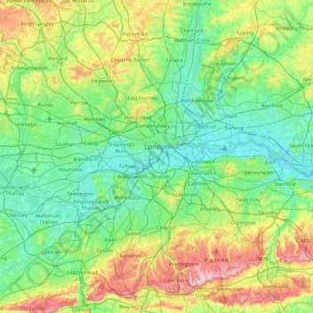
Name: London topographic map, elevation, terrain.
Location: London, Greater London, England, United Kingdom (51.28676 -0.51038 51.69187 0.33402)
Average elevation: 66 m
Minimum elevation: -2 m
Maximum elevation: 269 m
Make a donation
Gear up for your next adventure:
As an Amazon Associate, this site earns from qualifying purchases at no extra cost to you.
Other topographic maps
Click on a map to view its topography, its elevation and its terrain.
Plymouth
United Kingdom > England > Devon > Plymouth
The River Plym, which flows off Dartmoor to the north-east, forms a smaller estuary to the east of the city called Cattewater. Plymouth Sound is protected from the sea by the Plymouth Breakwater, in use since 1814. In the Sound is Drake's Island which is seen from Plymouth Hoe, a flat public area on top of…
Average elevation: 81 m
Pennines
United Kingdom > England > Westmorland and Furness
The Pennine climate is generally temperate like that of the rest of England, but the hills have more precipitation, stronger winds and colder weather than the surrounding areas. Higher elevations have a tundra climate. More snow falls on the Pennines than on surrounding lowland areas due to the elevation and…
Average elevation: 761 m
Leeds
Lying in the eastern foothills of the Pennines, there is a significant variation in elevation within the city's built-up area. The district ranges from 1,115 feet (340 m) in the far west on the slopes of Ilkley Moor to about 33 feet (10 m) where the rivers Aire and Wharfe cross the eastern boundary. Land rises…
Average elevation: 94 m
Make a donation
Gear up for your next adventure:
As an Amazon Associate, this site earns from qualifying purchases at no extra cost to you.
Cambridge
United Kingdom > England > Cambridge
The city, like most of the UK, has a maritime climate highly influenced by the Gulf Stream. Located in the driest region of Britain, Cambridge's rainfall averages around 570 mm (22.44 in) per year, around half the national average, with some years occasionally falling into the semi-arid (under 500 mm (19.69…
Average elevation: 18 m
Make a donation
Gear up for your next adventure:
As an Amazon Associate, this site earns from qualifying purchases at no extra cost to you.
Holme Fen
United Kingdom > England > Cambridgeshire > East Cambridgeshire > Haddenham
Average elevation: 4 m
Make a donation
Gear up for your next adventure:
As an Amazon Associate, this site earns from qualifying purchases at no extra cost to you.
Make a donation
Gear up for your next adventure:
As an Amazon Associate, this site earns from qualifying purchases at no extra cost to you.
Reading
United Kingdom > England > Reading
Mary Russell Mitford lived in Reading for a number of years and then spent the rest of her life just outside the town at Three Mile Cross and Swallowfield. The fictional Belford Regis of her eponymous novel, first published in 1835, is largely based on Reading. Described with topographical accuracy, it is…
Average elevation: 56 m
Make a donation
Gear up for your next adventure:
As an Amazon Associate, this site earns from qualifying purchases at no extra cost to you.
Hull
United Kingdom > England > Kingston upon Hull
Kingston upon Hull is on the northern bank of the Humber Estuary. The city centre is west of the River Hull and close to the Humber. The city is built upon alluvial and glacial deposits which overlie chalk rocks but the underlying chalk has no influence on the topography. The land within the city is generally…
Average elevation: 21 m
Make a donation
Gear up for your next adventure:
As an Amazon Associate, this site earns from qualifying purchases at no extra cost to you.
Make a donation
Gear up for your next adventure:
As an Amazon Associate, this site earns from qualifying purchases at no extra cost to you.
Reigate
United Kingdom > England > Surrey > Reigate and Banstead
Reigate is in central Surrey, around 19 mi (30 km) south of central London and 9 mi (14 km) north of Gatwick Airport. The town is in the Vale of Holmesdale, below the North Downs escarpment. The average elevation in the centre is 80 m (260 ft) above ordnance datum (OD) and the area is drained by the Wallace…
Average elevation: 100 m
Make a donation
Gear up for your next adventure:
As an Amazon Associate, this site earns from qualifying purchases at no extra cost to you.
The Warren
United Kingdom > England > Kent > Folkestone and Hythe District > Folkestone
Average elevation: 46 m
Make a donation
Gear up for your next adventure:
As an Amazon Associate, this site earns from qualifying purchases at no extra cost to you.
Make a donation
Gear up for your next adventure:
As an Amazon Associate, this site earns from qualifying purchases at no extra cost to you.
Little Clowes Wood
United Kingdom > England > Metropolitan Borough of Solihull > Tidbury Green
Average elevation: 150 m
Barden Lake
United Kingdom > England > Kent > Tonbridge and Malling > Tonbridge
Average elevation: 33 m
Bradgate Park
United Kingdom > England > Leicestershire > Charnwood > Newtown Linford
Overlying the Beacon Hill Formation, but found a little further down the hillside to the south, are the Bradgate Formation beds, the most notable of which is the Sliding Stone Slump Breccia rocks. Forming a line of crags below Old John, these are laminated mudstones, with layers of sandstone, mainly of…
Average elevation: 126 m
Make a donation
Gear up for your next adventure:
As an Amazon Associate, this site earns from qualifying purchases at no extra cost to you.
Sydenham
United Kingdom > England > Greater London
In the area where West Hill (later renamed Westwood Hill) and Crystal Palace Park Road raise in elevation and eventually meet, many fine villas were built in the latter half of the nineteenth century. Designed in revival architectural styles, fashionable at the time, most of the properties were three or four…
Average elevation: 45 m
Make a donation
Gear up for your next adventure:
As an Amazon Associate, this site earns from qualifying purchases at no extra cost to you.
Coulsdon
United Kingdom > England > Greater London
1804. The Surrey Iron Railway was enhanced by the "Coulsdon Merstham & Godstone Railway". These were horsedrawn railways which carried quarried materials and crops from Coulsdon and Merstham, and returned with fuel, metals and other materials. To maintain a regular elevation at Coulsdon required large changes…
Average elevation: 125 m
Ashton-under-Lyne
United Kingdom > England > Tameside
At 53°29′38″N 2°6′11″W / 53.49389°N 2.10306°W / 53.49389; -2.10306 (53.4941°, −2.1032°), and 160 miles (257 km) north-northwest of London, Ashton-under-Lyne stands on the north bank of the River Tame, about 35 feet (11 m) above the river. Described in Samuel Lewis's A Topographical…
Average elevation: 129 m
Make a donation
Gear up for your next adventure:
As an Amazon Associate, this site earns from qualifying purchases at no extra cost to you.
Uxbridge
United Kingdom > England > Greater London
Uxbridge lies at a mean elevation of 130 feet (40 m) above mean sea level. Like much of the rest of the UK its climate is generally temperate, with few extremes of temperature or weather.
Average elevation: 44 m
Make a donation
Gear up for your next adventure:
As an Amazon Associate, this site earns from qualifying purchases at no extra cost to you.
Werrington
United Kingdom > England > Staffordshire > Staffordshire Moorlands
Average elevation: 229 m
Make a donation
Gear up for your next adventure:
As an Amazon Associate, this site earns from qualifying purchases at no extra cost to you.
Richmond
United Kingdom > England > London
The town centre lies just below 33 ft (10m) above sea level. South of the town centre, rising from Richmond Bridge to an elevation of 165 ft (50m), is Richmond Hill. Just beyond the summit of Richmond Hill is Richmond Park, an area of 2,360 acres (9.55 km2; 3.7 sq mi) of wild heath and woodland originally…
Average elevation: 17 m
Bradford
Bradford is located at 53°45′00″N 01°50′00″W / 53.75000°N 1.83333°W / 53.75000; -1.83333 (53.7500, -1.8333)1. Topographically, it is located in the eastern moorland region of the South Pennines.
Average elevation: 167 m
Make a donation
Gear up for your next adventure:
As an Amazon Associate, this site earns from qualifying purchases at no extra cost to you.
Make a donation
Gear up for your next adventure:
As an Amazon Associate, this site earns from qualifying purchases at no extra cost to you.
Bude
United Kingdom > England > Cornwall
Its earlier importance was as a harbour, and then a source of sea sand useful for improving the inland soil. This was transported on the Bude Canal. The Victorians favoured it as a seaside resort. With new rail links, it became a popular seaside destination in the 20th century. Bradshaw's Guide of 1866,…
Average elevation: 41 m
Make a donation
Gear up for your next adventure:
As an Amazon Associate, this site earns from qualifying purchases at no extra cost to you.
Make a donation
Gear up for your next adventure:
As an Amazon Associate, this site earns from qualifying purchases at no extra cost to you.
Make a donation
Gear up for your next adventure:
As an Amazon Associate, this site earns from qualifying purchases at no extra cost to you.
Make a donation
Gear up for your next adventure:
As an Amazon Associate, this site earns from qualifying purchases at no extra cost to you.
Make a donation
Gear up for your next adventure:
As an Amazon Associate, this site earns from qualifying purchases at no extra cost to you.
Lockington
United Kingdom > England > Leicestershire > North West Leicestershire
Average elevation: 47 m
Make a donation
Gear up for your next adventure:
As an Amazon Associate, this site earns from qualifying purchases at no extra cost to you.
New Ferry
New Ferry is on the eastern side of the Wirral Peninsula, on the western bank of the River Mersey. The area is approximately 9 km (5.6 mi) south-south-east of the Irish Sea at New Brighton and about 10 km (6.2 mi) east-north-east of the Dee Estuary at Heswall. The area lies at an elevation of between 0–27 m…
Average elevation: 25 m
Make a donation
Gear up for your next adventure:
As an Amazon Associate, this site earns from qualifying purchases at no extra cost to you.
Make a donation
Gear up for your next adventure:
As an Amazon Associate, this site earns from qualifying purchases at no extra cost to you.