Geolocate

Telham topographic map

Click on the map to display elevation.

About this map

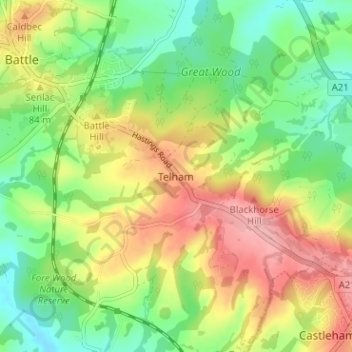
Name: Telham topographic map, elevation, terrain.

Location: Telham, Rother, East Sussex, England, TN33 0FN, United Kingdom (50.88403 0.49169 50.92403 0.53169)

Average elevation: 68 m

Minimum elevation: 9 m

Maximum elevation: 145 m

Other topographic maps

Click on a map to view its topography, its elevation and its terrain.

Westfield

United Kingdom > England > East Sussex > Rother > Westfield

Average elevation: 48 m

Camber

United Kingdom > England > East Sussex > Rother

Average elevation: 1 m

Bewl Water

United Kingdom > England > East Sussex > Rother > Ticehurst

Average elevation: 92 m

Playden

United Kingdom > England > East Sussex > Rother

Average elevation: 17 m

Burwash

United Kingdom > England > East Sussex > Rother > Burwash

Average elevation: 83 m

Iden

United Kingdom > England > East Sussex > Rother > Iden

Average elevation: 17 m

Bodiam

United Kingdom > England > East Sussex > Rother

Average elevation: 27 m

Guestling

United Kingdom > England > East Sussex > Rother > Guestling

Average elevation: 40 m

Northiam

United Kingdom > England > East Sussex > Rother

Average elevation: 34 m

Ticehurst

United Kingdom > England > East Sussex > Rother

Average elevation: 81 m

Mountfield

United Kingdom > England > East Sussex > Rother > Mountfield

Average elevation: 63 m

Guestling

United Kingdom > England > East Sussex > Rother > Guestling

Average elevation: 39 m

Pett

United Kingdom > England > East Sussex > Rother

Average elevation: 21 m

Catsfield

United Kingdom > England > East Sussex > Rother > Catsfield

Average elevation: 53 m

Hurst Green

United Kingdom > England > East Sussex > Rother > Hurst Green

Average elevation: 54 m

Brede

United Kingdom > England > East Sussex > Rother

Average elevation: 40 m

Icklesham

United Kingdom > England > East Sussex > Rother

Average elevation: 26 m

Ring Wood

United Kingdom > England > East Sussex > Rother > Crowhurst

Average elevation: 24 m

Bewl Water

United Kingdom > England > East Sussex > Rother > Ticehurst

Average elevation: 92 m

Rye

United Kingdom > England > East Sussex > Rother > Playden

The town and its striking surroundings have frequently served as subject for painters, many of whose works are now on display in its art gallery. One of the earliest topographical panoramas, dating from the 17th century when the town was still an island port, is in the style of Hendrick Danckerts and on…

Average elevation: 7 m

Battle

United Kingdom > England > East Sussex > Rother > Battle

Average elevation: 66 m

Rye

United Kingdom > England > East Sussex > Rother > Playden

The town and its striking surroundings have frequently served as subject for painters, many of whose works are now on display in its art gallery. One of the earliest topographical panoramas, dating from the 17th century when the town was still an island port, is in the style of Hendrick Danckerts and on…

Average elevation: 7 m

Rye

United Kingdom > England > East Sussex > Rother

The town and its striking surroundings have frequently served as subject for painters, many of whose works are now on display in its art gallery. One of the earliest topographical panoramas, dating from the 17th century when the town was still an island port, is in the style of Hendrick Danckerts and on…

Average elevation: 7 m

Udimore

United Kingdom > England > East Sussex > Rother

Average elevation: 23 m

Catsfield

United Kingdom > England > East Sussex > Rother

Average elevation: 53 m

Whatlington

United Kingdom > England > East Sussex > Rother

Average elevation: 53 m

Brightling

United Kingdom > England > East Sussex > Rother

Average elevation: 94 m

Sedlescombe

United Kingdom > England > East Sussex > Rother

Average elevation: 47 m

Peasmarsh

United Kingdom > England > East Sussex > Rother > Peasmarsh

Average elevation: 24 m

Udimore

United Kingdom > England > East Sussex > Rother

Average elevation: 23 m

Battle

United Kingdom > England > East Sussex > Rother > Battle

Average elevation: 66 m

Etchingham

United Kingdom > England > East Sussex > Rother

Average elevation: 46 m

Fairlight

United Kingdom > England > East Sussex > Rother

Average elevation: 47 m

Dallington

United Kingdom > England > East Sussex > Rother

Average elevation: 109 m

Camber Sands

United Kingdom > England > East Sussex > Rother > Camber

Average elevation: 2 m

Battle

United Kingdom > England > East Sussex > Rother > Battle

Average elevation: 66 m

Gear up for your next adventure:

🔦Everyday Carry Torches - Reliable backup light for your hiking pack
👣Waterproof Leg Gaiters - Keep bog water and debris out of your boots
🧭Route Planning Books - Plan the best hiking routes
🌧️Rain Gear for Hiking - Waterproof gear sets for wet hikes
🎒Waterproof Backpacks - Protect your gear from rain on Irish hikes

As an Amazon Associate, this site earns from qualifying purchases at no extra cost to you.