
Rye topographic map
Click on the map to display elevation.
Rye
The town and its striking surroundings have frequently served as subject for painters, many of whose works are now on display in its art gallery. One of the earliest topographical panoramas, dating from the 17th century when the town was still an island port, is in the style of Hendrick Danckerts and on display in Rye Castle Museum. Later landscapists who recorded views of the town have included Thomas Girtin, William Daniell, and J. M. W. Turner. During the 20th century, the harbour and its marshy surroundings were a particular draw for such artists as Paul Nash, Eric Ravilious and John Piper. In addition, Edward Burra lived near Rye and frequently painted its marshy surroundings, buildings in the town and even local characters.
About this map
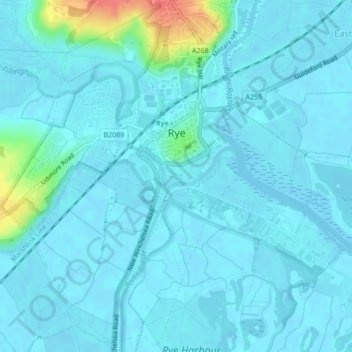
Name: Rye topographic map, elevation, terrain.
Location: Rye, Rother, East Sussex, England, United Kingdom (50.93478 0.71150 50.96085 0.74795)
Average elevation: 7 m
Minimum elevation: -1 m
Maximum elevation: 56 m
Other topographic maps
Click on a map to view its topography, its elevation and its terrain.
Highwoods SSSI
United Kingdom > England > East Sussex > Rother > Bexhill-on-Sea
Average elevation: 28 m
Northbridge Street
United Kingdom > England > East Sussex > Rother > Robertsbridge
Average elevation: 40 m
John's Cross
United Kingdom > England > East Sussex > Rother > Mountfield > John's Cross
Average elevation: 53 m
Union Street
United Kingdom > England > East Sussex > Rother > Flimwell > Union Street
Average elevation: 97 m
Battle of Hastings
United Kingdom > England > East Sussex > Rother > Catsfield
Battle Abbey was founded by William at the site of the battle. According to 12th-century sources, William made a vow to found the abbey, and the high altar of the church was placed at the site where Harold had died. More likely, the foundation was imposed on William by papal legates in 1070. The topography of…
Average elevation: 60 m