
Borough of Luton topographic map
Interactive map
Click on the map to display elevation.
About this map
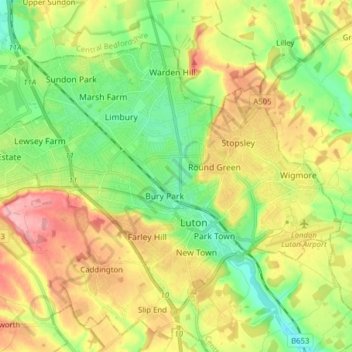
Name: Borough of Luton topographic map, elevation, terrain.
Location: Borough of Luton, England, United Kingdom (51.85447 -0.50595 51.92774 -0.34992)
Average elevation: 146 m
Minimum elevation: 94 m
Maximum elevation: 215 m
The local climate around Luton is differentiated somewhat from much of South East England due to its position in the Chiltern Hills, meaning it tends to be 1–2 degrees Celsius cooler than the surrounding towns – often flights at Luton airport, lying 160 m (525 ft) above sea level, will be suspended when marginal snow events occur, while airports at lower elevations, such as Heathrow, at 25 m (82 ft) above sea level, continue to function. An example of this is shown in the photograph to the right, the snowline being about 100 m (328 ft) above sea level. Absolute temperature extremes recorded at Rothamsted Research Station, 5 miles (8 km) south south east of Luton town centre and at a similar elevation range from −17.0 °C (1.4 °F) in December 1981 and −16.7 °C (1.9 °F) in January 1963 to 36.6 °C (97.9 °F) in July 2019 and 33.8 °C (92.8 °F) in August 1990 and July 2006. Records for Rothamsted date back to 1901.
Other topographic maps
Click on a map to view its topography, its elevation and its terrain.
London
United Kingdom > England > London
London, Greater London, England, SW1A 2DX, United Kingdom
Average elevation: 42 m
London
London, Greater London, England, United Kingdom
Average elevation: 66 m
Birmingham
Birmingham, West Midlands Combined Authority, England, United Kingdom
Average elevation: 138 m
Liverpool
Liverpool, Liverpool City Region, England, United Kingdom
Average elevation: 26 m
Cambridge
United Kingdom > England > Cambridge
Cambridge, Cambridgeshire, East of England, England, United Kingdom
Average elevation: 18 m
Peterborough
United Kingdom > England > City of Peterborough
Peterborough, City of Peterborough, Cambridgeshire and Peterborough, England, PE1 1XH, United Kingdom
Average elevation: 17 m
Lincolnshire
Lincolnshire, East Midlands, England, United Kingdom
Average elevation: 28 m
Reading
United Kingdom > England > West Berkshire > Reading
Reading, West Berkshire, South East England, England, RG1 1DA, United Kingdom
Average elevation: 56 m
Sheffield
Sheffield, South Yorkshire, England, United Kingdom
Average elevation: 168 m
Ipswich
United Kingdom > England > Suffolk
Ipswich, Suffolk, England, United Kingdom
Average elevation: 29 m
Ealing
Ealing, Greater London, England, W5 5DG, United Kingdom
Average elevation: 26 m
Milton Keynes
United Kingdom > England > Milton Keynes > Milton Keynes
Milton Keynes, South East England, England, MK9 3AF, United Kingdom
Average elevation: 81 m
East of England
East of England, England, United Kingdom
Average elevation: 39 m
Nuneaton
United Kingdom > England > Warwickshire > Nuneaton and Bedworth
Nuneaton, Nuneaton and Bedworth, Warwickshire, England, CV11 5AB, United Kingdom
Average elevation: 101 m
City of London
United Kingdom > England > City of London > City of London
City of London, England, EC2V 5AE, United Kingdom
Average elevation: 42 m
Spalding
United Kingdom > England > Lincolnshire > South Holland
Spalding, South Holland, Lincolnshire, England, United Kingdom
Average elevation: 4 m
Norwich
United Kingdom > England > Norfolk
Norwich, Norfolk, England, United Kingdom
Average elevation: 28 m
Nottingham
United Kingdom > England > Nottinghamshire
Nottingham, England, United Kingdom
Average elevation: 56 m
Brentwood
United Kingdom > England > Essex
Brentwood, Essex, England, United Kingdom
Average elevation: 64 m
Greater Manchester
Greater Manchester, England, United Kingdom
Average elevation: 141 m
Ely
United Kingdom > England > Ely
Ely, Cambridgeshire, East of England, England, United Kingdom
Average elevation: 13 m
Bristol
United Kingdom > England > City of Bristol
Bristol, City of Bristol, West of England, England, United Kingdom
Average elevation: 55 m
Oxford
United Kingdom > England > Oxfordshire
Oxford, Oxfordshire, England, United Kingdom
Average elevation: 81 m
The Cotswolds National Landscape
United Kingdom > England > Gloucestershire
The Cotswolds National Landscape, Gloucestershire, West of England, England, United Kingdom
Average elevation: 109 m
Northamptonshire
Northamptonshire, England, United Kingdom
Average elevation: 97 m
Warminster
United Kingdom > England > Wiltshire
Warminster, Wiltshire, England, United Kingdom
Average elevation: 143 m
Buckinghamshire
United Kingdom > England > Buckinghamshire
Buckinghamshire, Greater London, England, United Kingdom
Average elevation: 103 m
Dartmoor National Park
United Kingdom > England > Devon
Dartmoor National Park, Devon, England, United Kingdom
Average elevation: 239 m
Northumberland
Northumberland, North of Tyne, England, United Kingdom
Average elevation: 141 m
Worksop
United Kingdom > England > Nottinghamshire > Bassetlaw
Worksop, Bassetlaw, Nottinghamshire, England, S80 1JB, United Kingdom
Average elevation: 56 m
Hastings
United Kingdom > England > East Sussex
Hastings, East Sussex, England, United Kingdom
Average elevation: 36 m
Bournemouth
United Kingdom > England > Bournemouth, Christchurch and Poole > Wick
Bournemouth, Wick, Bournemouth, Christchurch and Poole, England, United Kingdom
Average elevation: 17 m
Upgate
United Kingdom > England > Norfolk > Broadland > Swannington
Upgate, Swannington, Broadland, Norfolk, England, NR9 5AH, United Kingdom
Average elevation: 31 m
Leeds
United Kingdom > England > Leeds
Leeds, Yorkshire and the Humber, England, LS1 6AL, United Kingdom
Average elevation: 94 m
South East England
South East England, England, United Kingdom
Average elevation: 69 m
Welwyn Garden City
United Kingdom > England > Hertfordshire > Welwyn Hatfield
Welwyn Garden City, Welwyn Hatfield, Hertfordshire, England, AL8 6TP, United Kingdom
Average elevation: 89 m
Enfield
United Kingdom > England > London
Enfield, Greater London, England, EN2 6LD, United Kingdom
Average elevation: 39 m
Basingstoke
United Kingdom > England > Hampshire > Basingstoke and Deane
Basingstoke, Basingstoke and Deane, Hampshire, England, United Kingdom
Average elevation: 110 m