
Lobaye topographic map
Interactive map
Click on the map to display elevation.
About this map
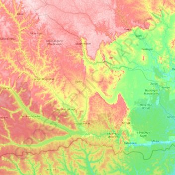
Name: Lobaye topographic map, elevation, terrain.
Location: Lobaye, Central African Republic (3.46924 16.74578 5.03595 18.62619)
Average elevation: 519 m
Minimum elevation: 337 m
Maximum elevation: 788 m
Other topographic maps
Click on a map to view its topography, its elevation and its terrain.
Bamingui-Bangoran
Bamingui-Bangoran, Central African Republic
Average elevation: 492 m
Réserve Spéciale de Dzanga-Sangha
Central African Republic > Sangha-Mbaéré
Réserve Spéciale de Dzanga-Sangha, Sangha-Mbaéré, Central African Republic
Average elevation: 486 m