Geolocate

Bamingui-Bangoran topographic map

Interactive map

Click on the map to display elevation.

About this map

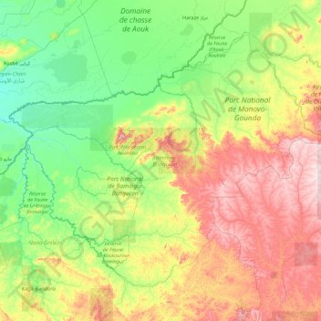
Name: Bamingui-Bangoran topographic map, elevation, terrain.

Location: Bamingui-Bangoran, Central African Republic (7.01906 18.86067 9.75993 22.38972)

Average elevation: 492 m

Minimum elevation: 366 m

Maximum elevation: 882 m

Other topographic maps

Click on a map to view its topography, its elevation and its terrain.

Lobaye

Central African Republic

Lobaye, Central African Republic

Average elevation: 519 m

Réserve Spéciale de Dzanga-Sangha

Central African Republic > Sangha-Mbaéré

Réserve Spéciale de Dzanga-Sangha, Sangha-Mbaéré, Central African Republic

Average elevation: 486 m