
Beaver County topographic map
Interactive map
Click on the map to display elevation.
About this map
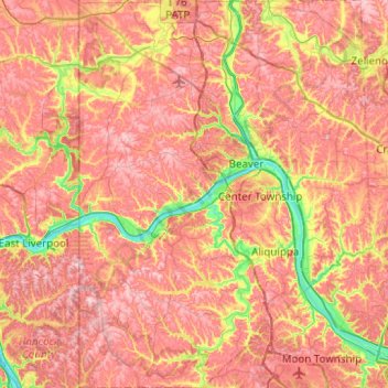
Name: Beaver County topographic map, elevation, terrain.
Location: Beaver County, Pennsylvania, United States (40.47717 -80.51934 40.85414 -80.14483)
Average elevation: 325 m
Minimum elevation: 201 m
Maximum elevation: 414 m
Other topographic maps
Click on a map to view its topography, its elevation and its terrain.
Cabot
United States > Pennsylvania > Butler County > Knox Chapel
Cabot, Knox Chapel, Winfield Township, Butler County, Pennsylvania, 16023, United States
Average elevation: 397 m
Fayette County
Fayette County, Pennsylvania, United States
Average elevation: 450 m
Dublin Township
United States > Pennsylvania > Huntingdon County
Dublin Township, Huntingdon County, Pennsylvania, United States
Average elevation: 331 m
Indian Mountain Lake
United States > Pennsylvania > Monroe County
Indian Mountain Lake, Monroe County, Pennsylvania, United States
Average elevation: 506 m
Lancaster
United States > Pennsylvania > Lancaster County
Lancaster, Lancaster County, Pennsylvania, United States
Average elevation: 102 m
Huntingdon County
Huntingdon County, Pennsylvania, United States
Average elevation: 380 m
Lehman Township
United States > Pennsylvania > Pike County
Lehman Township, Pike County, Pennsylvania, United States
Average elevation: 294 m
Manchester Township
United States > Pennsylvania > York County
Manchester Township, York County, Pennsylvania, 17318, United States
Average elevation: 135 m
Gettysburg
United States > Pennsylvania > Adams County
Gettysburg, Adams County, Pennsylvania, United States
Average elevation: 161 m
Columbia County
Columbia County, Pennsylvania, United States
Average elevation: 306 m
Lewistown
United States > Pennsylvania > Mifflin County
Lewistown, Mifflin County, Pennsylvania, 17044, United States
Average elevation: 181 m
Pittsburgh
United States > Pennsylvania > Allegheny County
Pittsburgh, Allegheny County, Pennsylvania, United States
Average elevation: 303 m
Buck
United States > Pennsylvania > Lancaster County > Buck
Buck, Lancaster County, Pennsylvania, 17531, United States
Average elevation: 219 m
Skunk Pond (Elevation 1100 feet)
United States > Pennsylvania > Westmoreland County > Murrysville
Skunk Pond (Elevation 1100 feet), Murrysville, Westmoreland County, Pennsylvania, United States
Average elevation: 323 m
York
United States > Pennsylvania > York County
York, York County, Pennsylvania, 17401, United States
Average elevation: 130 m
Elk Lick Township
United States > Pennsylvania > Elk Lick Township
Elk Lick Township, Somerset County, Pennsylvania, United States
Average elevation: 743 m
Cumberland County
Cumberland County, Pennsylvania, United States
Average elevation: 240 m
Carbon County
Carbon County, Pennsylvania, United States
Average elevation: 387 m
Irishtown
United States > Pennsylvania > Irishtown
Irishtown, Lancaster County, Pennsylvania, 17529:17572, United States
Average elevation: 117 m
Summerhill
United States > Pennsylvania > Summerhill
Summerhill, Cambria County, Pennsylvania, United States
Average elevation: 541 m
Churchtown
United States > Pennsylvania > Lancaster County > Caernarvon Township
Churchtown, Caernarvon Township, Lancaster County, Pennsylvania, 17555, United States
Average elevation: 163 m
Windgap
United States > Pennsylvania > Pittsburgh
Windgap, Pittsburgh, Allegheny County, Pennsylvania, United States
Average elevation: 258 m
Dunmore
United States > Pennsylvania > Dunmore
Dunmore, Lackawanna County, Pennsylvania, 18512, United States
Average elevation: 312 m
Harrisburg
United States > Pennsylvania > Harrisburg
Harrisburg, Dauphin County, Pennsylvania, United States
Average elevation: 123 m
Johnstown
United States > Pennsylvania > Cambria County
Johnstown, Cambria County, Pennsylvania, United States
Average elevation: 469 m